Category:Weidenberg
Jump to navigation
Jump to search
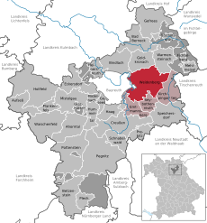
market municipality in Landkreis Bayreuth in Germany | |||||
| Upload media | |||||
| Instance of |
| ||||
|---|---|---|---|---|---|
| Part of |
| ||||
| Location | Bayreuth, Upper Franconia, Bavaria, Germany | ||||
| Population |
| ||||
| Area |
| ||||
| Elevation above sea level |
| ||||
| official website | |||||
 | |||||
Subcategories
This category has the following 15 subcategories, out of 15 total.
- Fischbach (Weidenberg) (1 F)
B
L
- Landscapes of Weidenberg (62 F)
M
- Miscellanea (Weidenberg) (10 F)
S
V
- Views of Weidenberg (14 F)
Media in category "Weidenberg"
The following 32 files are in this category, out of 32 total.
-
Bahnhof Stockau IMG 4393.jpg 3,888 × 2,592; 4.05 MB
-
Bahnhof Stockau IMG 4397.jpg 3,888 × 2,592; 3.88 MB
-
Bayreuth - Sept. 2020 - Blick auf Ützdorf.jpg 5,472 × 3,080; 10.43 MB
-
Bayreuth - Sept. 2020 - Höflas - Döhlau - Görau.jpg 5,472 × 3,080; 12.72 MB
-
Digitales Orthofoto von Weidenberg (Bayerische Vermessungsverwaltung).tif 32,500 × 30,000; 1.72 GB
-
GER Weidenberg, Fichtelgebirgsbahn 001.jpg 4,032 × 3,024; 2.57 MB
-
GER Weidenberg, Gewerbegebiet 001.jpg 3,865 × 2,899; 2.89 MB
-
GER Weidenberg, Gewerbegebiet 002.jpg 4,032 × 3,024; 2.74 MB
-
GER Weidenberg, Sonnige Lehne 001.jpg 3,988 × 2,991; 2.7 MB
-
Glaswanderweg Weidenberg.jpg 2,448 × 3,264; 1.47 MB
-
Glotzdorf IMG 4367.jpg 3,529 × 2,332; 2.95 MB
-
Infoboard Esche.jpg 1,701 × 2,486; 1.19 MB
-
Infoboard Espe.jpg 1,967 × 2,835; 1.19 MB
-
Infoboard Fichte.jpg 1,826 × 3,049; 1.61 MB
-
Infoboard Linde.jpg 2,447 × 2,918; 2.11 MB
-
Infoboard Nussbaum.jpg 1,471 × 1,832; 670 KB
-
Infoboard Robinie.jpg 1,911 × 2,631; 1.22 MB
-
Infoboard Rotbuche.jpg 1,578 × 2,071; 859 KB
-
Infoboard Schwarzerle.jpg 2,207 × 3,042; 1.73 MB
-
Infoboard Stieleiche.jpg 2,379 × 2,651; 1.83 MB
-
Infoboard Ulme.jpg 1,489 × 1,984; 807 KB
-
Infoboard Vogelbeere.jpg 1,656 × 2,159; 887 KB
-
Infoboard Vogelkirsche.jpg 1,973 × 2,742; 1.27 MB
-
Infoboard Waldkiefer.jpg 2,019 × 2,681; 1.38 MB
-
Infoboard Weide.jpg 2,447 × 3,173; 1.79 MB
-
Rastplatz am Rügersberg - panoramio.jpg 4,608 × 3,456; 3.18 MB
-
Rastplatz am Waldesrand - panoramio.jpg 2,048 × 1,536; 988 KB
-
Rastplatz Wüstung Neuhaus - panoramio.jpg 2,048 × 1,536; 921 KB
-
Stockau (Weidenberg).jpg 4,032 × 3,024; 2.06 MB
-
Stockau.jpg 4,032 × 3,024; 8.68 MB
-
Weidenberg - Feb. 2020 - Warme Steinach.jpg 3,080 × 5,472; 12.26 MB
-
Weidenberg.jpg 2,515 × 2,418; 1.54 MB


