
קובץ:LocationComoros.png
אין גרסה ברזולוציה גבוהה יותר.
LocationComoros.png (250 × 119 פיקסלים, גודל הקובץ: 5 ק"ב, סוג MIME: image/png)
זהו קובץ שמקורו במיזם ויקישיתוף. תיאורו בדף תיאור הקובץ המקורי (בעברית) מוצג למטה
ויקישיתוף הוא מאגר תמונות וקובצי מדיה חופשיים. אתם יכולים לעזור. |
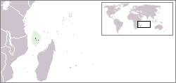
Locator map for the Comoros.
Originally created for English Wikipedia by Vardion.
| |
תמונה זו שוחררה לרשות הציבור על ידי היוצר שלה, Vardion במיזם אנגלית Wikimedia Commons. זה תקף בכל העולם. במקרה ששחרור לרשות הציבור לא אפשרי מבחינה חוקית: |

|
File:LocationComoros.svg הוא גרסה וקטורית של קובץ זה. יש להשתמש בו במקום הקובץ הזה PNG כאשר הוא אינו נחות.
File:LocationComoros.png → File:LocationComoros.svg
למידע נוסף, אנא ראו Help:SVG. |
 |
היסטוריית הקובץ
ניתן ללחוץ על תאריך/שעה כדי לראות את הקובץ כפי שנראה באותו זמן.
| תאריך/שעה | תמונה ממוזערת | ממדים | משתמש | הערה | |
|---|---|---|---|---|---|
| נוכחית | 16:22, 5 במרץ 2008 | | 119 × 250 (5 ק"ב) | Panos84 | Location of the island nation of Comoros and its exclusive economic zone. |
| 01:00, 12 בדצמבר 2004 |  | 115 × 250 (6 ק"ב) | EugeneZelenko | Location map for the Comoros.<br/>Originally created for English Wikipedia by Vardion.<br/>{{PD}}<br/>Category:Country locator maps |
שימוש בקובץ
הדף הבא משתמש בקובץ הזה:
שימוש גלובלי בקובץ
אתרי הוויקי השונים הבאים משתמשים בקובץ זה:
- שימוש באתר ar.wikipedia.org
- שימוש באתר bg.wikipedia.org
- שימוש באתר bn.wikivoyage.org
- שימוש באתר bpy.wikipedia.org
- שימוש באתר bs.wikipedia.org
- שימוש באתר ceb.wikipedia.org
- שימוש באתר de.wikinews.org
- שימוש באתר de.wiktionary.org
- שימוש באתר en.wikipedia.org
- שימוש באתר en.wikivoyage.org
- שימוש באתר en.wiktionary.org
- שימוש באתר eo.wikipedia.org
- שימוש באתר es.wikipedia.org
- שימוש באתר eu.wiktionary.org
- שימוש באתר frp.wikipedia.org
- שימוש באתר fr.wikipedia.org
- שימוש באתר fr.wiktionary.org
- שימוש באתר hif.wikipedia.org
- שימוש באתר hr.wiktionary.org
- שימוש באתר hu.wikipedia.org
צפייה בשימושים גלובליים נוספים של קובץ זה.