Blizzard threatens 64 million Americans with heavy snowfall, hazardous ice: ‘Please stay home!’
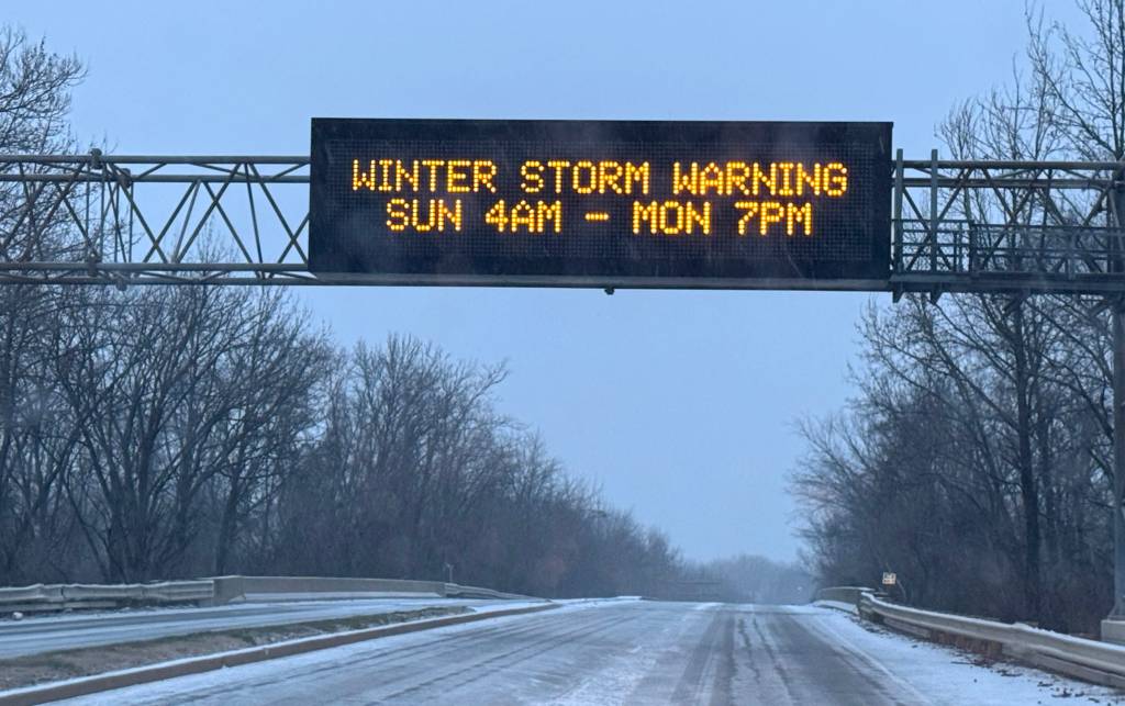
The first significant winter storm of the year is endangering a 2,100-mile swath of the country from the Northwest and Plains through the mid-Atlantic and East Coast, bringing a multitude of life-threatening hazards across major metropolitan areas, including heavy snow, near-blizzard conditions and crippling ice accretions that could lead to extended power outages.
The storm system worked its way through the northern Rockies and central Plains during the first half of the weekend, hours after slamming the West Coast and even spawning the first tornado of the year in California.
Freezing drizzle arrived in Wichita, Kansas, on Saturday morning, turning roadways into a sheet of ice and giving a preview of the headaches that loom as the storm moves east.
“We cannot stress this enough, law enforcement is working many, many accidents across metro Wichita,” NWS Wichita meteorologists pleaded on X. “Please stay home!”
Troopers worked to shut down parts of Interstate 70 in Kansas due to a series of crashes, which put a strain on resources.
“I-70 – Salinas, Saline, Dickenson, Lincoln, Russel County — all those counties on I-70 have significant crashes happening,” said Trooper Ben Gardner with the Kansas Highway Patrol.
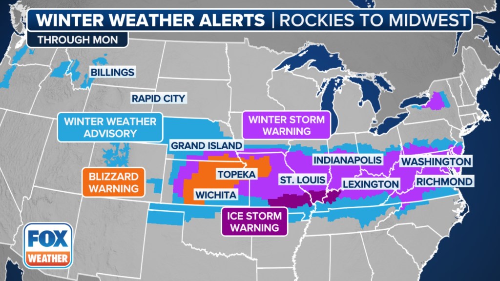
More than 64 million residents were placed under winter weather alerts, including Winter Storm Warnings and Ice Storm Warnings, with major impacts expected between interstates 50 and 70.
Dozens of counties in Kansas and Missouri are under Blizzard Warnings on Sunday due to visibilities dropping to less than a quarter-mile with plenty of blowing snow.
Salina and Wichita are both included in the alerts, where winds gusting upwards of 50 mph are possible through early Monday.
It is the first time in several years that parts of the Wichita and Kansas City metros have been placed under a Blizzard Warning.
South of the heavy band of snow, ice is expected to be problematic and could accumulate to nearly an inch from southern Missouri through Kentucky and into West Virginia. The heavy glaze will likely lead to power outages, and due to the nature of the terrain, outages could last for an extended period.
Arctic air following the winter storm will keep a large part of the northern tier of the country below freezing for several days, causing additional hardships for those unprepared for the winter wallop.
In preparation for the event, governors in Kansas, Missouri, Arkansas, Kentucky and Virginia declared states of emergency. Maryland Gov. Wes Moore declared a state of preparedness in advance of the winter storm.
Biggest snowfall event of season so far
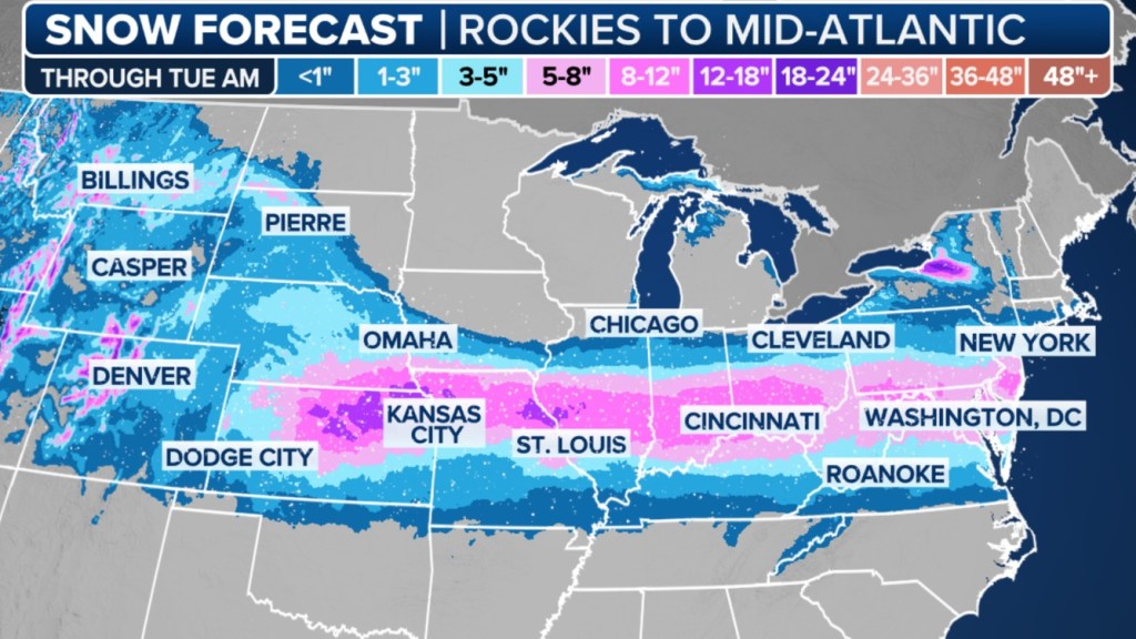
Snowfall totals are expected to approach a foot for communities in Kansas, Missouri, Illinois, Ohio and parts of West Virginia – making this winter blast the most significant event of the season and, for some areas, perhaps the largest snowfall in over a decade, according to NOAA’s Weather Prediction Center.
Isolated higher amounts are expected in the Appalachians and along the Great Lakes, where the terrain’s influence will be in full effect.
Many towns and cities in the path of the storm system have issued snow emergencies, as crews treat major roadways and prepare for round-the-clock snow removal efforts.
“This is the big one,” Chief Safety and Operations Officer Becky Allmeroth, with the Missouri Department of Transportation, told FOX Weather on Friday. “We are messaging out ahead of time, letting motorists know that our travel is going to be just about impossible on some of our major interstates: Interstate 70, because of the volume of snow, and Interstate 44 – that’s really the prime bull’s-eye right now for some of those heavier amounts of ice.”
Between 5 and 8 inches of snow is expected across the metro areas of St. Louis, Louisville and Lexington, with even higher amounts possible around Indianapolis and Kansas City. The snowfall is even expected to reach Philadelphia and Washington, D.C., where 3-6 inches is possible through Monday evening, with isolated higher amounts.
“I think Monday is going to be a snow day for a lot of (school) districts,” FOX Weather Storm Specialist Mike Seidel said. “All the way from Kansas, all the way east into (Washington) D.C., Baltimore and even Atlantic City.”
Significant amounts of ice could knock out power
South of the heavy snowfall, an ice storm looks likely, with hours of freezing rain expected, the FOX Forecast Center said.
Ice accretions of at least a half-inch are expected in parts of southern Missouri, southern Illinois and into the Appalachians, potentially leading to widespread tree damage and long-lasting power outages.
“When you get a half-inch of ice, you’re going to have power outages,” Seidel said. “Especially as that storm cranks up and moves by, we’re going to have a strong wind … and that is going to lead to more issues because you’ve got all the ice on the limbs and the limbs are getting blown around, and they will tend to crack and take out power lines.”
Due to the ice accretion, the airfield at Kansas City International Airport (MCI) was closed to inbound and outbound flights for several hours on Saturday. Kansas City Mayor Quinton Lucas said on X that crews were able to treat the airfield surfaces, runways and taxiways at MCI and were able to reopen the facility to resume flights late Saturday afternoon.
A combination of mechanical issues and the weather appeared to cause the Kansas City Chiefs to be delayed at MCI for hours before taking off for Denver for their match against the Broncos on Sunday.
Major airlines, including Delta, United, Southwest and American, were allowing travelers to adjust schedules ahead of the winter storm, but the efforts did not prevent long lines from forming at ticket counters amid thousands of delays and cancellations over the weekend.
Unlike previous winter weather events this season, there doesn’t appear to be much warm air on the horizon, which means much of the snowfall will stay on the ground throughout a significant portion of the month.
“A lot of times after a storm, yeah, it gets cold for (one or two) days,” Seidel said. “This arctic outbreak is going to come in and sit here all week … so whatever falls is going to stick around.”
Severe thunderstorm risk across South
On the warm side of the storm system, thunderstorms are expected to develop on Sunday and Monday in portions of the South.
Some of these storms are expected to meet severe criteria, with gusty winds and the potential for tornadoes.
NOAA’s NOAA Storm Prediction Center has issued a Level 3 out of 5 risk for severe storms for parts of northern Louisiana, western Mississippi and southeastern Arkansas, with a Level 2 risk stretching from East Texas to far western Alabama.
These thunderstorms are expected to impact regions recently affected by a tornado outbreak in late December.
Severe thunderstorms across the South are not unusual during the winter months, as the region is in its tornado season.


