Hoppa till innehållet

Fil:India location map.svg

Sidans innehåll stöds inte på andra språk.
Från Wikivoyage, den fria resehandboken.

Originalfil (SVG-fil, standardstorlek: 1 500 × 1 615 pixlar, filstorlek: 1,23 Mbyte)

Den här filen är från Wikimedia Commons och kan användas av andra projekt. Beskrivningen på dess filbeskrivningssida där visas nedan.

Sammanfattning

Beskrivning
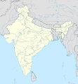
English: Location map of India.

Equirectangular projection. Strechted by 106.0%. Geographic limits of the map:

  • N: 37.5° N
  • S: 5.0° N
  • W: 67.0° E
  • E: 99.0° E
Made with Natural Earth. Free vector and raster map data @ naturalearthdata.com.
Datum
Källa Eget arbete
Skapare Uwe Dederingtyska Wikipedia
Andra versioner

Filer som bygger på denna fil:

[redigera]

Licensiering

Uwe Dederingtyska Wikipedia, upphovsrättsinnehavaren av detta verk, publicerar härmed det under följande licenser:
GNU head Tillstånd ges att kopiera, distribuera och/eller modifiera detta dokument under villkoren i GNU Free Documentation License, Version 1.2 eller senare version publicerad av Free Software Foundation, utan oföränderliga avsnitt, framsidestexter eller baksidestexter. En kopia av licensen ingår i avsnittet GNU Free Documentation License.
w:sv:Creative Commons
erkännande dela lika
Denna fil har gjorts tillgänglig under licensen Creative Commons Erkännande-Dela Lika 3.0 Unported
Erkännande: Uwe Dederingtyska Wikipedia
Du är fri:
  • att dela – att kopiera, distribuera och sända verket
  • att remixa – att skapa bearbetningar
På följande villkor:
  • erkännande – Du måste ge lämpligt erkännande, ange en länk till licensen och indikera om ändringar har gjorts. Du får göra det på ett lämpligt sätt, men inte på ett sätt som antyder att licensgivaren stödjer dig eller din användning.
  • dela lika – Om du remixar, transformerar eller bygger vidare på materialet måste du distribuera dina bidrag under samma eller en kompatibel licens som originalet.
w:sv:Creative Commons
erkännande dela lika
Denna fil har gjorts tillgänglig under licensen Creative Commons Erkännande-Dela Lika 3.0 Tyskland.
Erkännande: Uwe Dederingtyska Wikipedia
Du är fri:
  • att dela – att kopiera, distribuera och sända verket
  • att remixa – att skapa bearbetningar
På följande villkor:
  • erkännande – Du måste ge lämpligt erkännande, ange en länk till licensen och indikera om ändringar har gjorts. Du får göra det på ett lämpligt sätt, men inte på ett sätt som antyder att licensgivaren stödjer dig eller din användning.
  • dela lika – Om du remixar, transformerar eller bygger vidare på materialet måste du distribuera dina bidrag under samma eller en kompatibel licens som originalet.
Du får själv välja den licens du vill använda.

Depiction of India's borders

  • The territorial boundaries of India are shown as per the actual ground situation in accordance with international practices followed by the United Nations and the National Geographic Society
  • This map is meant to be for illustrative purpose only and is not authenticated by official government sources. Please check the list of sources and references used to create the map for a measure of accuracy and verifiability.
  • The usage of these maps in India, Pakistan and China are governed by different laws that restrict depictions of boundaries other than what is officially recognized by the state. Please check local laws and modify the map accordingly before use.

Explanation of disputed boundaries

  • Boundary of Indian claim : The territory India claims is legally theirs, but the claim is disputed by China and Pakistan.
  • Line of Control/Line of Conflict : The de facto administrative boundary recognised by the international community. This UN ceasefire line is considered as a temporary solution to an ongoing conflict since the departure of the British Raj.

Borders of disputed regions

The extent of the former territory of the British Indian Empire, seceeded by Republic of India depicted on this map may not be accepted by most countries as legal due to ongoing border disputes:

  • The northern Himalayan region of the disputed territory Indian-administered Kashmir is claimed by India including (Pakistan-administered Kashmir) and the Chinese Occupied territory of (Ladakh plateau). It is currently divided between all three countries since 1972. See also Line of Control and Line of Actual Control.
  • Siachen glacier (shown white) is an actively contested region between India and Pakistan. At present the region is in control of India since 1984.
  • The northeastern territory of Arunachal Pradesh is almost entirely claimed by China as part of its Tibetan territory.
  • Minor areas of eastern Ladakh, Himachal Pradesh and Uttarakhand on the Chinese frontier are claimed by China. These areas are under Indian control.
  • A small area of Uttarakhand adjoining the Nepal border along the Sarda river is disputed between the two countries.

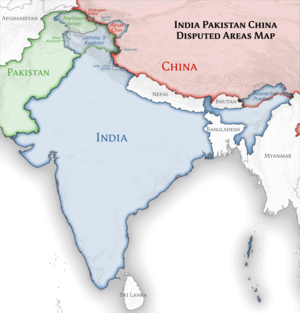
For a detailed map of all disputed regions in South Asia, see Image:India disputed areas map.svg

Internal borders

The borders of the state of Meghalaya, Assam and Arunachal Pradesh are shown as interpreted from the North-Eastern Areas (Reorganisation) Act, 1971, but has yet to be verified.

Territorial waters

The limit of the territorial waters of India extends to twelve nautical miles measured from the appropriate baseline. See this archive copy at the Wayback Machine for more information.

Ursprunglig uppladdningslogg

Överförd från de.wikipedia till Commons av Uwe Dedering.

Den ursprungliga beskrivningssidan fanns här. Alla följande användarnamn finns på de.wikipedia.
  • 2010-02-21 16:39 Uwe Dedering 1500×1615× (2412750 bytes) {{Information |Beschreibung = very little borders style changes |Quelle = |Urheber = |Datum = |Genehmigung = |Andere Versionen = |Anmerkungen = }}
  • 2010-02-21 14:16 Uwe Dedering 1500×1615× (2411518 bytes) {{Information |Beschreibung = North now 37.5, changed disputed areas |Quelle = |Urheber = |Datum = |Genehmigung = |Andere Versionen = |Anmerkungen = }}
  • 2010-02-20 16:44 Uwe Dedering 1500×1540× (2246850 bytes) {{Information |Beschreibung = Location map of India. Equirectangular projection. Strechted by 106.0%. Geographic limits of the map: * N: 36.0° N * S: 5.0° N * W: 67.0° E * E: 99.0° E Made with Natural Earth. Free vector and raster map data @ nat

Bildtexter

Ingen bildtext har definierats

Objekt som porträtteras i den här filen

motiv

Filhistorik

Klicka på ett datum/klockslag för att se filen som den såg ut då.

(Senaste | Tidigaste) Visa (10 nyare | ) (10 | 20 | 50 | 100 | 250 | 500)
Datum/TidMiniatyrbildDimensionerAnvändareKommentar
nuvarande4 april 2021 kl. 10.24Miniatyrbild för versionen från den 4 april 2021 kl. 10.241 500 × 1 615 (1,23 Mbyte)TKsdik8900Fulfilling the edit request (File talk:India location map.svg#Upload more compact version of India location map) by C1MM
14 oktober 2020 kl. 17.50Miniatyrbild för versionen från den 14 oktober 2020 kl. 17.501 500 × 1 615 (1,64 Mbyte)NordNordWestcorrect Telangana/Andhra Pradesh
4 november 2019 kl. 00.10Miniatyrbild för versionen från den 4 november 2019 kl. 00.101 500 × 1 615 (1,62 Mbyte)RaviCslight colour change for consistency
4 november 2019 kl. 00.06Miniatyrbild för versionen från den 4 november 2019 kl. 00.061 500 × 1 615 (1,62 Mbyte)RaviC== {{int:filedesc}} == {{Information |Description={{en|Location map of India. Equirectangular projection. Strechted by 106.0%. Geographic limits of the map: * N: 37.5° N * S: 5.0° N * W: 67.0° E * E: 99.0° E Made with Natural Earth. Free vector and raster map data @ naturalearthdata.com.}} |Source={{own}} |Date=2010-02-20 |Author={{user at project|Uwe Dedering|wikipedia|de}} |Permission= |other_versions={{DerivativeVersions|India location map2.svg|India location map 3.png}} {{Other versions/I...
19 augusti 2014 kl. 22.42Miniatyrbild för versionen från den 19 augusti 2014 kl. 22.421 500 × 1 615 (1,59 Mbyte)M0ttyUpdate by Sémhur : add the state of Telangana
7 juni 2011 kl. 12.51Miniatyrbild för versionen från den 7 juni 2011 kl. 12.511 500 × 1 615 (1,49 Mbyte)NordNordWestNagaland corrected
18 januari 2011 kl. 17.10Miniatyrbild för versionen från den 18 januari 2011 kl. 17.101 500 × 1 615 (2,36 Mbyte)Uwe DederingReverted to version as of 15:50, 17 January 2011 and again, layer structure destroyed, and first discuss this!
17 januari 2011 kl. 20.04Miniatyrbild för versionen från den 17 januari 2011 kl. 20.041 500 × 1 615 (1,52 Mbyte)AshwiniKalantriThe disputed land of Kashmir are shown in a different shade.
17 januari 2011 kl. 16.50Miniatyrbild för versionen från den 17 januari 2011 kl. 16.501 500 × 1 615 (2,36 Mbyte)Uwe DederingReverted to version as of 11:34, 22 September 2010 vandalism
17 januari 2011 kl. 00.30Miniatyrbild för versionen från den 17 januari 2011 kl. 00.301 500 × 1 615 (2,01 Mbyte)AshwiniKalantri{{Information |Description=Location Map of India |Source= |Date= |Author= |Permission= |other_versions= }}
(Senaste | Tidigaste) Visa (10 nyare | ) (10 | 20 | 50 | 100 | 250 | 500)

Följande sidor länkar till den här bilden:

Global filanvändning

Metadata