We model changes in vegetation, land use and land cover, including changes due to wildfire.
We model changes in vegetation, land use and land cover, including changes due to wildfire.
Vegetation, land use, and land cover change
ApexRMS develops and supports an open-source software tool, called ST-Sim, for creating and running spatially-explicit simulation models of landscape change. ST-Sim uses a state-and-transition simulation model (STSM) approach to forecast landscape dynamics, including projecting changes in both vegetation and land use/land cover. Because the STSM method is inherently stochastic, it is well suited for characterizing uncertainty in model projections.
STSMs have been applied to a wide range of landscapes and management questions, including forests, rangelands, grasslands, wetlands, aquatic communities and urban areas, over spatial extents ranging from thousands to millions of hectares. Additional details on the STSM approach can be found in the paper by Daniel, Frid, Sleeter, and Fortin (2016) (also summarized in a 13 minute video). The integration of STSMs with stock-flow models of continuous variables, such as biomass and carbon, can be found in a second paper by Daniel, Sleeter, Frid, and Fortin (2018).
We designed ST-Sim, a package that plugs into the SyncroSim modeling framework. As a result, it can run under both Windows and Linux; it can also be run from the R programming language using the rsyncrosim R package and from the Python programming language using the pysyncrosim Python package. The ongoing development of ST-Sim has been generously supported by several agencies, including the U.S. Geological Survey, The Nature Conservancy, and the U.S. Forest Service.
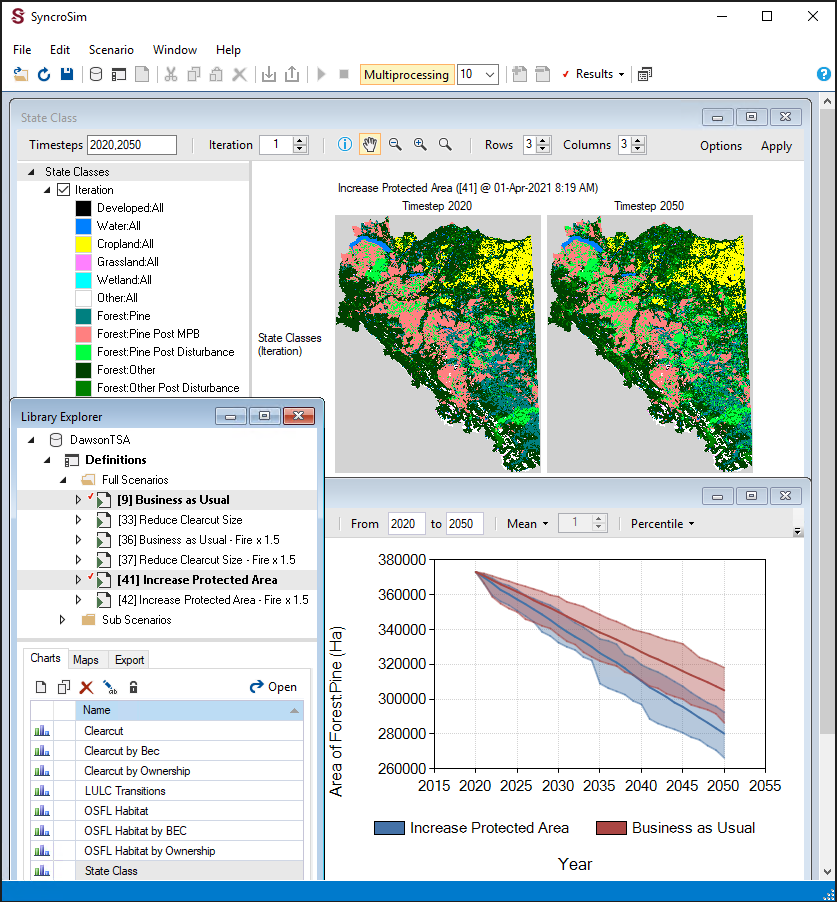
Landscape changes simulated for varying forecast scenarios using the SyncroSim package, ST-Sim.
Selected Clients:









Wildfire
Scientists and land managers working in fire-prone areas require map-based estimates of wildfire risk, including forecasts of how this risk could change in response to possible future changes in climate, vegetation and management. To support this requirement, ApexRMS, in collaboration with the Canadian Forest Service, has developed BurnP3+, an open-source SyncroSim Package for modeling landscape-level wildfire risk. As with the legacy Burn-P3 model it was designed to replace, BurnP3+ uses a simulation-based burn probability modelling approach to estimate fire risk. By leveraging the built-in features of the SyncroSim modeling framework, BurnP3+ allows fire modelers to compare and contrast alternative fire growth models, create modeling workflows in programming languages such as Python and R, and connect their fire behavior models dynamically to models of landscape change.
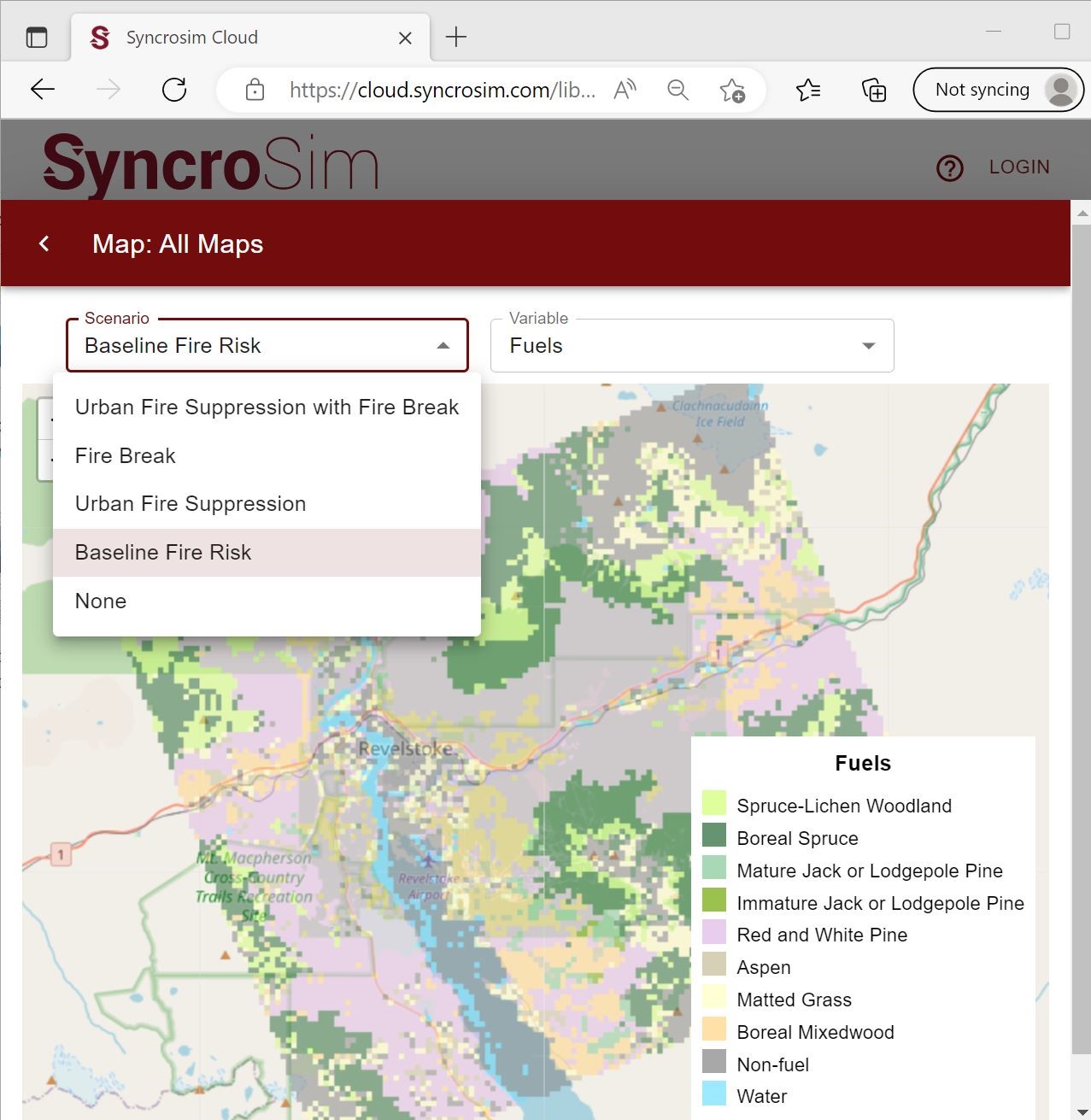
An example of a wildfire fuels map used as input for wildfire modeling with the SyncroSim package, BurnP3+, and displayed within the SyncroSim web interface.
Featured Project: A general software framework for burn probability modeling in Canada
Selected Clients:

Vegetation, land use, and land cover change
ApexRMS develops and supports an open-source software tool, called ST-Sim, for creating and running spatially-explicit simulation models of landscape change. ST-Sim uses a state-and-transition simulation model (STSM) approach to forecast landscape dynamics, including projecting changes in both vegetation and land use/land cover. Because the STSM method is inherently stochastic, it is well suited for characterizing uncertainty in model projections.
STSMs have been applied to a wide range of landscapes and management questions, including forests, rangelands, grasslands, wetlands, aquatic communities and urban areas, over spatial extents ranging from thousands to millions of hectares. Additional details on the STSM approach can be found in the paper by Daniel, Frid, Sleeter, and Fortin (2016) (also summarized in a 13 minute video). The integration of STSMs with stock-flow models of continuous variables, such as biomass and carbon, can be found in a second paper by Daniel, Sleeter, Frid, and Fortin (2018).
We designed ST-Sim, a package that plugs into the SyncroSim modeling framework. As a result, it can run under both Windows and Linux; it can also be run from the R programming language using the rsyncrosim R package and from the Python programming language using the pysyncrosim Python package. The ongoing development of ST-Sim has been generously supported by several agencies, including the U.S. Geological Survey, The Nature Conservancy, and the U.S. Forest Service.

Landscape changes simulated for varying forecast scenarios using the SyncroSim package, ST-Sim.
Selected Clients:
Selected Clients:

Wildfire
Scientists and land managers working in fire-prone areas require map-based estimates of wildfire risk, including forecasts of how this risk could change in response to possible future changes in climate, vegetation and management. To support this requirement, ApexRMS, in collaboration with the Canadian Forest Service, has developed BurnP3+, an open-source SyncroSim Package for modeling landscape-level wildfire risk. As with the legacy Burn-P3 model it was designed to replace, BurnP3+ uses a simulation-based burn probability modelling approach to estimate fire risk. By leveraging the built-in features of the SyncroSim modeling framework, BurnP3+ allows fire modelers to compare and contrast alternative fire growth models, create modeling workflows in programming languages such as Python and R, and connect their fire behavior models dynamically to models of landscape change.

An example of a wildfire fuels map used as input for wildfire modeling with the SyncroSim package, BurnP3+, and displayed within the SyncroSim web interface.
Featured Project: A general software framework for burn probability modeling in Canada
Selected Clients:

Selected Clients:
