In October 1948, talking about Plymouth City Council rising to the challenge of rehousing local people after the war, Pat Twyford wrote: “Take a tour the length of Blandford Road from Lower Compton to Laira; walk the length of the main road from Crownhill to St Budeaux.
“Try to find your way through the intricate windings of the estate which fills the country between the St Budeaux-Crownhill main road and Pennycross,” the author and journalist added. “You will find yourself in new habitations; you will be bewildered. The achievement meeting the housing needs of Plymouth has indeed been notable.”
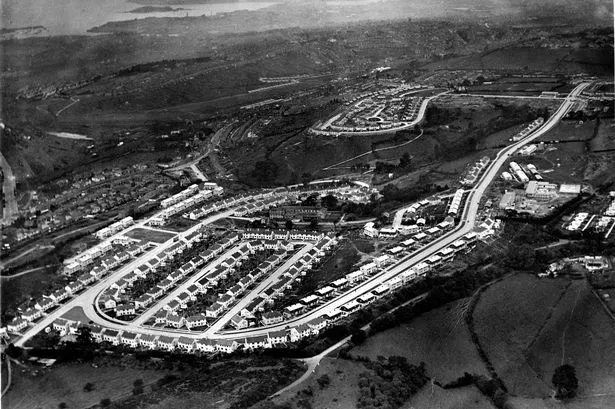
The earlier image, taken around that time, shows just how shiny and new Blandford Road was back then; and, note, barely a car in sight! Blandford Road, then as now, curves around into Pike Road, sitting inside the line of Military Road, with Efford Fort sitting just below the fork in that road in the middle of the picture.


This had been a rural area, with Deer Park Farm a little to the north-east, Efford Manor and the later Efford Colony seen here east of Thames Gardens, with Lower Crabtree sitting above the end of the Embankment, below Manifold Gardens. The erstwhile Efford Farm and Little Efford occupied the wooded area seen here to the right of the looping road that is Severn Place, with Erme Gardens located within it.
It is interesting to note that almost all the housing development was carried out on open fields, and that the major wooded areas were preserved, hence the designation of what is now Efford Park and the more recent Efford Marsh Local Nature Reserve which runs down across what was Efford Warren to Marsh Mills, around Efford Fort.
As Pat Twyford noted some 75 years ago, though, to his readers then, there would have been very few who could not remember this as a rural idyll beyond the Plymouth boundary!


