File:Roman Republic Empire map.gif
From Wikimedia Commons, the free media repository
Jump to navigation
Jump to search
Roman_Republic_Empire_map.gif (626 × 595 pixels, file size: 101 KB, MIME type: image/gif, looped, 21 frames, 37 s)
File information
Structured data
Captions
Captions
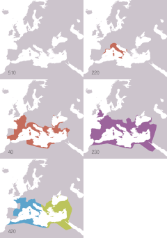
Animated map of the Roman Republic and Empire
Ρωμαϊκή αυτοκρατορία
La république romaine et son empire (510 av.jc/530ap.jc)
The Roman Republic and Empire (510BC-40BC).
Roma İmperiyası
La República y el Imperio Romanos (510 a. C.-530 d. C.)
Roman samarajya k naksha
Roma Cumhuriyeti ve İmparatorluğu'nun animasyonlu haritası. Haritada gösterilenler: Roma Cumhuriyeti MÖ 510-MÖ 40 Roma İmparatorluğu MS 20- MS 360 Doğu Roma İmparatorluğu MS 405-MS 1453 Batı Roma İmparatorluğu MS 405-MS 480
Römisches Reich
Summary
[edit]| DescriptionRoman Republic Empire map.gif |
English: Animated map of the Roman Republic and Empire. Displayed in the map:
Español: Mapa animado de la República y el Imperio Romanos.
Français : Carte animée de la république puis de l'empire Romain. Русский: Анимированные карты Римской республики и империи. Отображаются на карте:
|
| Date | |
| Source |
English:
Español:
Français :
Русский: 日本語:
|
| Author | Roke (d) |
| Other versions |
English: Version including the Byzantine Empire is at Image:Roman Empire map.gif. Español: Image:Roman Empire map.gif: versión que incluye al Imperio Bizantino. Français : Image:Roman Empire map.gif : version incluant l'empire byzantin. Русский: В том числе версия Византийской империи: Image:Roman Empire map.gif 日本語: ビザンチン帝国を含む地図 : Image:Roman Empire map.gif。 |
| Camera location | 47° 00′ 00″ N, 18° 00′ 00″ E | View this and other nearby images on: OpenStreetMap |
|---|
Licensing
[edit]I, the copyright holder of this work, hereby publish it under the following license:

|
Permission is granted to copy, distribute and/or modify this document under the terms of the GNU Free Documentation License, Version 1.2 or any later version published by the Free Software Foundation; with no Invariant Sections, no Front-Cover Texts, and no Back-Cover Texts. A copy of the license is included in the section entitled GNU Free Documentation License.http://www.gnu.org/copyleft/fdl.htmlGFDLGNU Free Documentation Licensetruetrue |
| This file is licensed under the Creative Commons Attribution-Share Alike 3.0 Unported license. | ||
| ||
| This licensing tag was added to this file as part of the GFDL licensing update.http://creativecommons.org/licenses/by-sa/3.0/CC BY-SA 3.0Creative Commons Attribution-Share Alike 3.0truetrue |
File history
Click on a date/time to view the file as it appeared at that time.
| Date/Time | Thumbnail | Dimensions | User | Comment | |
|---|---|---|---|---|---|
| current | 19:14, 22 November 2009 |  | 626 × 595 (101 KB) | Sémhur (talk | contribs) | Adding minus sign for BC years. |
| 09:56, 19 May 2007 |  | 626 × 595 (101 KB) | Roke~commonswiki (talk | contribs) | minor - colours of numbers off in last version | |
| 07:31, 19 May 2007 |  | 626 × 595 (71 KB) | Roke~commonswiki (talk | contribs) | fix area north of hadrians wall | |
| 14:29, 2 July 2006 |  | 800 × 760 (218 KB) | Roke~commonswiki (talk | contribs) | Reverted to earlier revision | |
| 12:05, 6 June 2006 |  | 800 × 760 (218 KB) | Roke~commonswiki (talk | contribs) | speed up rate to 1 second | |
| 10:58, 6 June 2006 |  | 800 × 760 (218 KB) | Roke~commonswiki (talk | contribs) | map of the Roman Empire based on Image:BlankMap-Europe-v3.png, displayed in the map: *Red = Roman republic 510BC-40BC *Purple = Roman Empire 20AD-360AD *Blue = Western Roman Empire 4 |
You cannot overwrite this file.
File usage on Commons
The following 8 pages use this file:
File usage on other wikis
The following other wikis use this file:
- Usage on af.wikipedia.org
- Usage on am.wikipedia.org
- Usage on anp.wikipedia.org
- Usage on an.wikipedia.org
- Usage on ar.wikipedia.org
- Usage on arz.wikipedia.org
- Usage on ast.wikipedia.org
- Usage on azb.wikipedia.org
- Usage on az.wikipedia.org
- Usage on bar.wikipedia.org
- Usage on ba.wikipedia.org
- Usage on be-tarask.wikipedia.org
- Usage on be.wikipedia.org
- Usage on bg.wikipedia.org
- Usage on bn.wikipedia.org
- Usage on bs.wikipedia.org
- Usage on ca.wikipedia.org
- Usage on cdo.wikipedia.org
- Usage on ckb.wikipedia.org
- Usage on cs.wikipedia.org
- Usage on cv.wikipedia.org
- Usage on cy.wikipedia.org
- Usage on da.wikipedia.org
View more global usage of this file.
