Editor’s Note: Today’s guest author is Greg Moore, President of the Golden Gate National Parks Conservancy. Google is excited to help support this celebration of the Golden Gate Bridge.

On May 27th, the San Francisco Golden Gate Bridge celebrated its 75th anniversary. Our organization, the non-profit ...


Editor’s Note: Today’s guest author is Greg Moore, President of the Golden Gate National Parks Conservancy. Google is excited to help support this celebration of the Golden Gate Bridge.

On May 27th, the San Francisco Golden Gate Bridge celebrated its 75th anniversary. Our organization, the non-profit Golden Gate National Parks Conservancy, is working with the Golden Gate Bridge, Highway and Transportation District; the National Park Service; the Presidio Trust; and the City of San Francisco to help commemorate this landmark event.

As president of the Golden Gate National Parks Conservancy, I have the privilege of enjoying the majestic architecture of the bridge and its landscape on a regular basis. This iconic Bridge stands at the center of the Golden Gate National Parks.

However, we’re pleased to announce that now the American spirit and beauty of the bridge will be available to everyone. Our new interactive website, Band of Bridges, brings the celebration of the Golden Gate Bridge’s 75th anniversary into everyone’s homes.


The website enables visitors to virtually connect bridges from around the world to the Golden Gate, making what we hope will be the longest bridge in history. Using the Google Maps API, users can navigate every corner of the Earth and search for bridges or enter a specific bridge they are already familiar with—maybe even one from their hometown. Each new bridge added will connect to preceding bridges, resulting in spans that stretch hundreds (or thousands) of digital miles.

With the U.S. Bureau of Transportation Statistics approximating 600,000 bridges in the United States alone, we hope to connect thousands of bridges and people from across the globe.

Just as the Golden Gate blends together its surrounding nature, culture and people, Band of Bridges, conceived by San Francisco advertising agency Goodby Silverstein & Partners and brought to life by the Google Maps team in Mountain View, is a culmination of the amazing creative and technological talent of the Bay Area in California.

The Golden Gate National Parks Conservancy would like to thank Goodby Silverstein & Partners and Google for bringing such vision, beauty and authenticity to our efforts.

Please join us in celebrating the Golden Gate Bridge’s 75th anniversary and be part of our Band of Bridges.

(Cross posted from Official Google Blog)

I’ve always been fascinated by famous historic and cultural sites from around the world. When I was a child, flipping through encyclopedias while researching for school projects, the thought of exploring these sites was a distant dream. With the new Google ...
(Cross posted from Official Google Blog)

I’ve always been fascinated by famous historic and cultural sites from around the world. When I was a child, flipping through encyclopedias while researching for school projects, the thought of exploring these sites was a distant dream. With the new Google World Wonders Project, that dream is now a little closer for students and others around the globe.

The World Wonders Project enables you to discover 132 historic sites from 18 countries, including Stonehenge, the archaeological areas of Pompeii and the ancient Kyoto temples. In addition to man-made sites, you can explore natural places: wander the sandy dunes of Australia’s Shark Bay or gaze up at the rock domes of Yosemite National Park in California.


World Wonders uses Street View technology to take you on a virtual trip to each iconic site. Most could not be filmed by car, so we used camera-carrying trikes to pedal our way close enough. The site also includes 3D models and YouTube videos of the historical places, so you can dig in and get more information and a broader view of each site. We also partnered with several prestigious organizations, including UNESCO, the World Monuments Fund, Getty Images and Ourplace, who provided official information and photographs for many of the sites.


We hope World Wonders will prove to be a valuable educational resource for students and scholars. A selection of educational packages are available to download for classroom use; you can also share the site content with friends.

World Wonders is part of our commitment to preserving culture online and making it accessible to everyone. Under the auspices of the Google Cultural Institute, we’re publishing high resolution images of the Dead Sea Scrolls, digitizing the archives of famous figures such as Nelson Mandela and presenting thousands of artworks through the Art Project.

Find out more about the project on the World Wonders YouTube channel, and start exploring at www.google.com/worldwonders.


Finding the best places to go is an essential part of our lives, as are the people and resources that help us make those decisions. In fact, the opinions of friends, family or other trusted sources are often the first we seek when looking for the perfect restaurant for date night or the cafe that makes the best latte ever.

Finding the best places to go is an essential part of our lives, as are the people and resources that help us make those decisions. In fact, the opinions of friends, family or other trusted sources are often the first we seek when looking for the perfect restaurant for date night or the cafe that makes the best latte ever.

Today, we’re rolling out Google+ Local, a simple way to discover and share local information featuring Zagat scores and recommendations from people you trust in Google+. Google+ Local helps people like my husband turn a craving—“Wow, I need brunch”—into an afternoon outing: “Perfect, there’s a dim sum place with great reviews just two blocks from here. Let’s go.” It’s integrated into Search, Maps and mobile and available as a new tab in Google+—creating one simple experience across Google.


Local information integrated across Google
From the new “Local” tab on the left-hand side of Google+, you can search for specific places or browse for ones that fit your mood. If you click on a restaurant, or a museum (or whatever), you’ll be taken to a local Google+ page that includes photos, Zagat scores and summaries, reviews from people you know, and other useful information like address and opening hours.

Google+ Local is also integrated across other products you already use every day. If you’re looking for a place on Search or Maps, you get the same great local information there too. You can also take it on the go with Google Maps for mobile on your Android device, and soon on iOS devices.

A search on Google Maps
Google+ Local on an Android phone


Better decisions with Zagat
Since Zagat joined the Google family last fall, our teams have been working together to improve the way you find great local information. Zagat has offered high-quality reviews, based on user-written submissions and surveys, of tens of thousands of places for more than three decades. All of Zagat’s accurate scores and summaries are now highlighted on local Google+ pages.


Each place you see in Google+ Local will now be scored using Zagat’s 30-point scale, which tells you all about the various aspects of a place so you can make the best decisions. For example, a restaurant that has great food but not great decor might be 4 stars, but with Zagat you’d see a 26 in Food and an 8 in Decor, and know that it might not be the best place for date night.

Recommendations and reviews from people you know and trust
Your friends know what you like, and they probably like the same things you do. That’s why the opinions of people in your circles are front and center. If you search for [tacos] on Google+ Local, your results might include a friend’s rave review of the Baja-style taco stand in your neighborhood.  And if you’re searching on Google or Google Maps for a great place to buy a gift for that same friend, your results might include a review from her about a boutique she shops at all the time.

You can also share your opinions and upload photos. These reviews and photos will help your friends when they’re checking out a place, and are also integrated into the aggregate score that other people see. The more you contribute, the more helpful Google+ Local will be for your friends, family and everyone else.


Whether it’s a block you’ve lived on for years or a city you’ve never been to before, we hope Google+ Local helps you discover new gems.

Today is just the first step, and you’ll see more updates in the coming months. If you’re a business owner, you can continue to manage your local listing information via Google Places for Business. Soon we’ll make it even easier for business owners to manage their listings on Google and to take full advantage of the social features provided by local Google+ pages. Get more information on our Google and Your Business Blog.


This summer, the eyes of soccer fans around the world will be trained on Poland and Ukraine as the royalty of European football descends on the country for the European Championships. This will be the first time either country has hosted the tournament as they welcome fans from 16 competing nations, including world champions Spain, Germany, England and the Netherlands.

This summer, the eyes of soccer fans around the world will be trained on Poland and Ukraine as the royalty of European football descends on the country for the European Championships. This will be the first time either country has hosted the tournament as they welcome fans from 16 competing nations, including world champions Spain, Germany, England and the Netherlands.

For those fans unable to attend but keen to sample what lies in store for the players and fans, we’ve captured the magic of the 8 stadiums with our Street View cars and trikes, to offer 360° street-level images of the grounds.

So now you can explore the NSC Olimpiyskiy (Olympic Stadium) in Kyiv -- which will play host for the tournament’s final -- in all its splendid detail:


And the famous National Stadium in Warsaw that will host the opening match:


And other stadia to be explored in Ukraine include the Donbass Arena, in Donetsk, the Metalist Stadium in Kharkiv and the Arena Lviv. While in Poland you can visit Poznan, Gdansk and Wroclaw.

As a bonus, many of Poland and Ukraine’s tournament stadiums have also been modelled in amazing 3D detail, allowing fans to fly in and out of these fantastic sports venues. To access the 3D imagery simply turn on the 3D buildings layer in Google Earth or switch to Earth View in Google Maps, and zoom in to the chosen destination -- like this one in Poznan.

We encourage you to start exploring right away, whether from your PC or your mobile phone, and enjoy everything that Poland and the Ukraine have to offer as it gets ready for the tournament kick-off. Also remember to visit our Street View gallery to see other places around the world.


This week’s 45° imagery update for Google Maps contains coverage for 16 U.S. and 10 international locations. This update also includes our first 45° imagery for Poland and Ireland.

This week’s 45° imagery update for Google Maps contains coverage for 16 U.S. and 10 international locations. This update also includes our first 45° imagery for Poland and Ireland.

Kraków, Poland
Located in the south at the foot of the Tatra Mountains, Kraków is the second largest city in Poland. Kraków features a rich heritage of medieval architecture from Renaissance, Baroque and Gothic times. The Gothic Wawel Royal Castle, shown below, is located on a hill above Vistula River served as the Polish residence when Kraków was the capital of the country.


View Larger Map

Dublin, Ireland
Founded by Vikings in the year of 842, the name of the town goes back to “Dubh Linn” that could be translated as “Black Swamp”. Dublin has been home to many world-class poets like Oscar Wilde, Samuel Beckett and James Joyce. It has also produced some modern-day poets like Bono. St. Patrick’s Cathedral – one of Ireland's most famous landmarks – is shown below.


View Larger Map

Santa Fe
Santa Fe, the capital of New Mexico, is located along the historic Santa Fe Trail – an important trade route for textiles in the 19th Century. Architecturally, Sante Fe is famous for the so-called the Pueblo, which features adobe-colored building exteriors. San Miguel Mission is the oldest church of the US dating back to around 1610 and erected in traditional adobe construction.


View Larger Map


Have fun exploring the new sites!

Below is the full list of updated cities:

US: Albany, GA (outskirts); Atascocita, TX; Clarksville, TN; Columbia, MO; Corpus Christi, TX; Fayetteville, NC; Fort Collins, CO; Fort Smith, AR; Greensboro, NC; Jackson, TN; Lafayette, LA; Plaquemine, LA; Pueblo, CO; Santa Fe, NM; Texarkana, AR; Tyler, TX

International: Bern, Switzerland; Cracow, Poland; Dublin, Ireland; Gdansk, Poland; Lugo, Spain; Ourense, Spain; Poznan, Poland; Warsaw, Poland; Wroclaw, Poland; Zurich, Switzerland

Posted by Bernd Steinert, Geo Data Specialist


Growing up in Indiana, my Dad and I shared a love of racing. Not just any kind of racing, but open-wheeled Indy Car racing. Every Memorial Day weekend, we'd get up early and drive from our home in Columbus to the Indianapolis Motor Speedway to watch our favorite spectacle in racing: the Indianapolis 500.

Growing up in Indiana, my Dad and I shared a love of racing. Not just any kind of racing, but open-wheeled Indy Car racing. Every Memorial Day weekend, we'd get up early and drive from our home in Columbus to the Indianapolis Motor Speedway to watch our favorite spectacle in racing: the Indianapolis 500.

I went to college in Indiana as well, and we were able to keep up the tradition. But when I moved to California, we just weren't able to make it work, and we haven’t been able to attend a race together since.

Luckily, now, I’m an Engineer on Google Street View, and so I’m sure you can imagine my excitement to let the world know that the Indianapolis Motor Speedway is now available through Street View.


Once, Dad managed to get some pit passes, and we wandered around the pits and garages before the race watching the final preparation on the cars, the mechanics scurrying to have everything ready and the drivers doing their pre-race routine. It was really cool and now that's on Street View, also.


From Jim Nabors’ opening song, to the finish line and the milk, this Memorial Day, you’ll find me watching the Indy 500 with my Dad. Explore the track in Street View now and then enjoy the race with us.


Congratulations to 8th grader Rahul Nagvekar, who was just named the 2012 National Geographic Bee champion! Rahul is 14 years old and from Missouri City, Texas. It’s a good thing he has a passion for traveling, as this year’s winner receives a trip to the Galapagos Islands, in addition to a lifetime membership to the ...

Congratulations to 8th grader Rahul Nagvekar, who was just named the 2012 National Geographic Bee champion! Rahul is 14 years old and from Missouri City, Texas. It’s a good thing he has a passion for traveling, as this year’s winner receives a trip to the Galapagos Islands, in addition to a lifetime membership to the National Geographic Society and a $25,000 college scholarship. To get here today, Rahul has answered more than 300 geography-related questions since the Bee started at Quail Valley Middle School last fall.


This year, over four million students around the United States participated in the National Geographic Bee. Participants in the qualifying rounds were asked a variety of questions, ranging from locations of carnivorous plants, spider monkeys, natural disasters, soil types, language dialects, labor reforms, and glaciers. Participants must have a vast amount of knowledge in order to successfully answer questions on such diverse topics.

Physical, human, and cultural geography encompasses much of what takes place on our planet. These nine to fourteen year olds have a wealth of knowledge about the world that extends way beyond their years. The last question of this year’s final was: “Name the Bavarian City on the Danube River that was the legislative seat for the Holy Roman Empire from 1663-1806.” The winning answer is, of course, Regensburg, in Bavaria, Germany.

Google is once again proud to sponsor the National Geographic Bee. This contest highlights the importance of being geographically literate, a skill that is vital for all students. We are all explorers and must invest in understanding the world around us. Technology, like Google Earth, allows us to virtually visit any place on the planet so we can make those connections between people and their environment.

You can watch the 2012 National Geographic Bee tonight, Thursday, May 24th at 8 p.m. ET/PT on the National Geographic Channel and Nat Geo WILD. It will also air later on public broadcasting stations.


Congratulations to Rahul and all of the other state finalists!


Today, we are excited to announce a new addition to the Google Earth Outreach Grants program. Now, eligible nonprofit organizations in the U.S., U.K., Brazil and Canada can apply for grants of ...

Today, we are excited to announce a new addition to the Google Earth Outreach Grants program. Now, eligible nonprofit organizations in the U.S., U.K., Brazil and Canada can apply for grants of Google Maps Engine, a platform formerly known as Google Earth Builder, for hosting, storing, managing, and styling map data.

Google Earth Builder has been available to businesses since August 2011. A new name is just the beginning. Several nonprofit organizations, including World Wildlife Fund and Eyes on the Forest (a coalition of Sumatran NGOs), as well as Living Oceans Society, have already been using the platform to tell stories and engage their constituents in an interactive way.

It's no secret that the natural habitats of wildlife such as tigers, rhinos, elephants and orangutans are disappearing at an alarming rate. The World Wildlife Fund, in partnership with Eyes on the Forest, uses Google Maps Engine to develop and publish Geographic Information Systems (GIS) data showing the reduction of ranges for these four endangered species. In addition, they are publishing maps on floral diversity and change in carbon stocks and forest cover over time.


While some nonprofits focus on terrestrial conservation, Living Oceans Society works to protect the British Columbia coastline. As GIS and mapping specialists, they create and publish maps such as kayak routes, dive sites, eelgrass beds, and oil and tanker traffic to inform residents of the recreational value of natural habitats as well as inform policy-makers about the risks that increasing industrial practices pose to the ecosystem.


With this addition of Google Maps Engine to the Google Earth Outreach Grants program, we’re releasing three new Google Maps Engine tutorials to educate nonprofits on how to use the product. We’ll also be hosting a Google+ Hangout on the Google Earth Plus page to provide more information about the program and answer questions from potential grant recipients. Tune in by visiting the Google Earth Plus page on May 24th at 10:30 a.m. PDT to join the Hangout on Air.

More information about eligibility for a Google Maps Engine grant and how organizations can apply is available on the Google Earth Outreach Maps Engine for Nonprofits page.


In 2008, the Google Earth Outreach team visited the Surui tribe in the Brazilian Amazon rainforest for the first time, upon request of Chief Almir Naramagoya Surui. Their goal was to learn how to share and preserve their culture using ...

In 2008, the Google Earth Outreach team visited the Surui tribe in the Brazilian Amazon rainforest for the first time, upon request of Chief Almir Naramagoya Surui. Their goal was to learn how to share and preserve their culture using Google Maps, Google Earth, and other online tools including Picasa, YouTube, and Blogger. We were honored to play a role in empowering the indigenous people of a region that had been ravaged by illegal logging to tell their stories to millions of people around the world. Filmmaker Denise Zmekhol documented this experience in a video called Trading Bows and Arrows for Laptops.

Then, in 2009, Rebecca Moore, head of the Google Earth Outreach team, returned to the Amazon to teach the Surui about Open Data Kit (ODK), a new suite of open-source tools that streamlines the process of data collection in the field with Android phones. Using ODK, the tribe takes pictures of what’s happening on the ground for proof of the illegal logging that is taking place on their territory.

The Surui also began using ODK and Google Earth to visualize the carbon reserves of the forest they live in. This process is part of their 50-year sustainability plan, and serves as a model for how indigenous tribes who have lost much of their ancestral land to logging and deforestation can thrive with the help of a new emerging market based on carbon credits.

Chief Almir, in his joint presentation with Rebecca Moore, celebrated the validation of the Surui Forest Carbon Project on Saturday, May 12th at TEDxBeloHorizonte in Brazil. This is a groundbreaking outcome for the Surui people for two reasons. First, this is the first indigenous-led project in the world to be validated. Equally important, it’s also the first REDD+ project in Brazil to get certified by both the Verified Carbon Standard (VCS) to sell stocks in the carbon market, and the Climate, Community and Biodiversity (CCB) Gold Standard to get extra gains from other ‘co-benefits’ of forest preservation, such as increasing biodiversity for a region, or preserving the livelihood of local communities who depend on the forest. The project was validated by Rainforest Alliance and the Brazilian NGO IMAFLORA.


The Surui and their partner IDESAM have already measured a baseline of carbon stored in the indigenous reserve and will avoid the emission of 6 million tons of carbon over the 30 years of the life of the project by avoiding the deforestation of 40 thousand hectares of forests and protecting an additional 200,000 hectares. Coordinated by Forest Trends, the Surui will work with the Brazilian government and those who want to neutralize their emissions to develop financial mechanisms to ensure the forest is protected and well managed, while also assuring the quality of life for the Surui community. The primary financial vehicle has been designed by FUNBIO, a Brazilian NGO specializing in creating financial mechanisms for conservation.

The TEDx talk was made on the heels of another Google Earth Outreach workshop held in Cacoal, Rondonia in May -- this one intended to teach the Surui people how to create a cultural map using Google Earth. Creating a new platform for storytelling online and an interactive repository for shared memories, the Surui students have interviewed their elders to map their ancestral sites, such as the site of first contact with western civilization in 1969, places where the tribes battled with colonists in the 1970s, as well as places of interest, like sightings of jaguars, capybaras and toucans. Once the Surui students have completed the first version of the map, it will be available for all to explore both as a Google Earth KML, powered by Spreadsheet Mapper 3.0, and as a narrated tour in Google Earth.


We are very excited for Chief Almir, the Surui people, and their partners, including ECAM, Amazon Conservation Team, Forest Trends, IDESAM, Kaninde, FUNBIO, among others, who are entering into a new phase of global significance with the validation of the Surui Forest Carbon Project and the Surui Cultural Map.


The Google Earth and Maps Imagery team recently published another batch of aerial and satellite imagery. In this post, we’ll focus on U.S. cities and locales, as the largest amount of new high resolution aerial imagery covers regions in the United States.

The Google Earth and Maps Imagery team recently published another batch of aerial and satellite imagery. In this post, we’ll focus on U.S. cities and locales, as the largest amount of new high resolution aerial imagery covers regions in the United States.

High on the list of things associated with the United States are over-sized automobile tail fins. Our first aerial image shown below is of Cadillac Ranch, located near Amarillo, Texas. The series of partly buried and tilted Cadillacs is a public art homage to the iconic American auto.

Cadillac Ranch, Texas

Our next example is of Downtown New Haven, Connecticut. The image shows the center park square of New Haven Green, which is surrounded by eight squares of the same size that comprise a nine-square downtown area that was first drawn out in 1638, and represents the first planned city in the United States.

Downtown New Haven, Connecticut

Few U.S. rivers are more well-known than the mighty Mississippi. The aerial image below, snapped last month, shows a portion of the river’s northern extent where it forms Saint Anthony Falls in Minneapolis, Minnesota. The Metrodome Stadium, home of the NFL franchise Minnesota Vikings, can be seen in the lower left corner. The team has played its last game there and is about to sign a 30-year deal to build a new downtown stadium.

Section of Downtown Minneapolis, Minnesota

The final example shown below is a section of the “Magic Dragon,” more commonly known as the Lake of the Ozarks. This sinuous man-made reservoir was formed by the damming of the Osage River in South-Central Missouri. More than 70,000 residences line the shoreline and the Bagnell Dam can be seen in the upper-right corner of the image.

Section of Lake of the Ozarks, Missouri

If you’d like to receive an email notification when the Google Earth and Maps Imagery team updates your favorite areas(s), we’ve got just the tool: The Follow Your World application!

These are only a few examples of the sites that can be seen and discovered in our latest batch of published imagery. Happy exploring!

High resolution aerial updates:
U.S. cities: Big Lake, TX; Bowie, TX; Bridgeport, CT; Cleveland, OH; Danville, VA; Dickinson, ND; Farmington, MO; Grand Forks, ND; Hartford, CT; Minneapolis, MN; Providence, RI; Quincy, IL; Richlands, VA; Traverse City, MI; Youngstown, OH

Countries/regions receiving high resolution satellite updates:

Albania, Algeria, Angola, Antarctica, Argentina, Armenia, Australia, Austria, Azerbaijan, Belarus, Belize, Bolivia, Bosnia and Herzegovina, Botswana, Brazil, Bulgaria, Burkina Faso, Cambodia, Cameroon, Canada, Chad, Chile, China, Colombia, Costa Rica, Cuba, Cyprus, Côte d'Ivoire, Democratic Republic of the Congo, Denmark, Dominican Republic, Egypt, El Salvador, Equatorial Guinea, Eritrea, Estonia, Ethiopia, Fiji, France, French Polynesia, Gabon, Georgia, Germany, Ghana, Greece, Guatemala, Guinea, Guinea-Bissau, Haiti, Honduras, Iceland, India, Indonesia, Iran, Ireland, Italy, Jamaica, Japan, Kazakhstan, Kenya, Kuwait, Latvia, Lebanon, Lesotho, Libya, Madagascar, Malawi, Malaysia, Maldives, Mali, Mauritania, Mexico, Mongolia, Morocco, Mozambique, Myanmar, Namibia, Nepal, New Caledonia, New Zealand, Niger, Nigeria, North Korea, Norway, Oman, Pakistan, Panama, Papua New Guinea, Paraguay, Peru, Philippines, Poland, Portugal, Qatar, Romania, Russia, Saudi Arabia, Senegal, Serbia, Solomon Islands, Somalia, South Africa, South Korea, Spain, Sri Lanka, Sudan, Svalbard, Swaziland, Sweden, Switzerland, Syria, Tanzania, Thailand, Turkey, Uganda, Ukraine, United Arab Emirates, United States, Uruguay, Uzbekistan, Vanuatu, Venezuela, Vietnam, Western Sahara, Yemen, Zambia, Zimbabwe

These updates are now available in both Google Maps and Google Earth. For a complete picture of where we updated imagery, download this KML for viewing in Google Earth.


You can now virtually visit the Baltic States of Estonia and Latvia using the Street View feature in Google Maps.

Lets start in Estonia with a peek into the capital of ...

You can now virtually visit the Baltic States of Estonia and Latvia using the Street View feature in Google Maps.

Lets start in Estonia with a peek into the capital of Tallinn, a medieval city characterized by its cobbled streets and red roofs. Here’s a view the Town Hall Square.


Also in Tallinn you have the Toompea Castle, which is a historic site built on top of the Toompea Hill and now houses the Parliament of Estonia.


Moving south to Latvia, lets first visit the square of Riga Dom Cathedral, which is one of favourite places both for locals and city guests to relax in an outdoor cafe, listen to live music and experience a true atmosphere of medieval old town.


Also, take a look at the bridge over river Gauja in Sigulda. Thanks to the picturesque valley, many newlyweds choose to cross the bridge, symbolizing their wedding as two shores coming together. If you ever happen to visit (at least on Street View), be sure that you will get only the warmest welcomes from wedding guests.


There are a ton more sites to visit through Street View and we hope this can inspire you to visit these two countries in the near future! To learn more about Street View please visit www.google.com/streetview.


Getaria, Gipuzkoa, Spain!

Over the past several months, hundreds of teams from all over the world have submitted stunning geo-models for our Google Model Your Town Competition. These examples of pure 3D civic pride are breathtaking to behold. Difficult as it was, the SketchUp team managed to pick six finalists, after which we asked the general public to vote for their favorite collection of models. Tens of thousands of you weighed in, and the talented team from the north of Spain were victorious.

Getaria, Gipuzkoa, Spain!

Over the past several months, hundreds of teams from all over the world have submitted stunning geo-models for our Google Model Your Town Competition. These examples of pure 3D civic pride are breathtaking to behold. Difficult as it was, the SketchUp team managed to pick six finalists, after which we asked the general public to vote for their favorite collection of models. Tens of thousands of you weighed in, and the talented team from the north of Spain were victorious. Zorionak! (That’s “Congratulations!” in Basque.)

Want to see how they won? Take a look at Team Getaria’s collection in the 3D Warehouse, pop over to our winners’ page, and watch this video to see their astounding work:


The winning team is a dynamic duo: Josetxo Perez Fernandez, 36, is a professional who works in computer administration; and Pedro Domecq Aguirre, 45, is a programmer, 3D data specialist and network administrator. Those are their day jobs, anyway. It turns out that they’re actually world-class, polygon-wrangling, texture-mapping, megabyte-optimizing, geo-modeling superheroes. And now they’re bona fide local heroes, too. Thanks to them, millions of people across the globe can now get familiar with the beautiful little town of Getaria.

The beautiful coastline of Getaria

Not only that, but we’ll also be awarding US$25,000 to a local school and hosting a celebration with the town of Geteria in honor of Pedro's and Josetxo's accomplishment.

Getaria Lighthouse on Mount San Antón

Zorionak to the winning town, to the other five finalists, and to all the other entrants who collectively modeled almost 25,000 local landmarks that are now available for all to enjoy in Google Earth’s 3D Buildings layer. The virtual world is a richer place thanks to your efforts, and the real one is a lot better off, too.


Posted by Allyson McDuffie, SketchUp Team


With Google Maps, we’ve made it increasingly easy to save and re-find the places that matter to you. Last year, we introduced the My Places tab which organizes your saved Custom Maps, directions that you’ve previously looked up, and locations you’ve starred, checked-in and rated. Starting today, you’ll also be able to save your home and work locations in Google Maps when signed in with your Google account.

With Google Maps, we’ve made it increasingly easy to save and re-find the places that matter to you. Last year, we introduced the My Places tab which organizes your saved Custom Maps, directions that you’ve previously looked up, and locations you’ve starred, checked-in and rated. Starting today, you’ll also be able to save your home and work locations in Google Maps when signed in with your Google account.


Imagine moving to a foreign country -- this means a new city, a new neighborhood, and even a new apartment to call home. That was how I began my summer last year, moving from Boulder, Colorado to Tokyo, Japan. In a new country where blocks, not streets, are labeled and addresses use a different formatting system, finding home was a feat in and of itself. And that’s how the idea to save home and work locations in Google Maps was born.

By saving these locations that are common to you in My Places, you’ll be able to access these addresses by simply typing “home” or “work” when searching or getting directions in Google Maps. Using these keywords will create a drop-down suggestion with the address you’ve set so that you no longer have to type the full address into the search box.


By saving your home and work locations in My Places, you’ll also see special icons to easily identify these locations on the map.


To set your home and work locations, you’ll need to sign in with your Google Account. Once logged in, click the My Places tab in Google Maps and save your home and work locations. From the My Places panel, you can also edit or delete your saved locations by clicking the drop-down to the right of the home or work icons.

With home and work locations saved in Google Maps, we hope to help you navigate your way to these frequently visited places, regardless of where you may be.

Update (5/15): Sorry for the delay, but home and work locations in My Places will be available soon. We'll update this post again when the feature is live.

Update (5/25): Thanks for your patience, home and work locations in My Places is now available.


Summertime means summer travel. Whether you're planning the next family trip or group outing, Google Maps can help. Street View’s immersive views lets you preview your adventure by transporting you to famous landmarks and tourist destinations around the world. Over the years, our ...

Summertime means summer travel. Whether you're planning the next family trip or group outing, Google Maps can help. Street View’s immersive views lets you preview your adventure by transporting you to famous landmarks and tourist destinations around the world. Over the years, our Partner Program has allowed us to showcase a growing number of notable amusement parks, zoos and other points of interest, with our 360-degree panoramic imagery.

For example, if you’re on the West Coast of the US and want to visit the world famous San Diego Zoo, search for “San Diego Zoo” , drag Pegmen to a spot inside the zoo, and take a tour. You can also virtually explore the zoos in Honolulu, Denver, Detroit and more.


If you’re looking for some amusement without the animals, take a peek at some of the largest amusement parks across the country. Visit Universal Studios in Orlando, Florida, and catch a glimpse of how movie magic is made. You can also preview with imagery from Six Flags Discovery Kingdom, Universal Studios Hollywood, Santa Cruz Beach Boardwalk, Great America, Busch Gardens, and Wet ‘n’ Wild Hawaii.


If you’re into high-octane trips to the racetrack, you can take a virtual look at Mazda Raceway Laguna Seca or Infineon Raceway. Or if peace and quiet is more your speed, you can take a leisurely stroll through Balboa Park, the Chicago Botanic Garden, or Diamond Head park and trail.


Wherever you choose to adventure, feel free to explore these popular U.S. locations from the comfort of your desktop or mobile device. Let Street View imagery help you decide where to go on your next summer getaway. To see more popular locations, check out our Street View Gallery.


Do you have a spreadsheet of locations that you’d like to see on a map? Here on the Google Earth Outreach team we talk to many nonprofits who use Google Earth ...

Do you have a spreadsheet of locations that you’d like to see on a map? Here on the Google Earth Outreach team we talk to many nonprofits who use Google Earth and Maps to tell their stories and visualize their data. Often the data is in spreadsheets, or other tabular formats. Converting these rows and columns into a map brings the spreadsheet to life by providing geographic context and a new way to visualize the information.

Spreadsheet Mapper is a tool that enables anyone to easily create a well-designed KML file to show off their data in Google Earth and Maps. Since Spreadsheet Mapper is a Google Docs template, you fill in your data using the familiar interface of a spreadsheet, and create a great KML without any coding. It gives you all the cloud-based benefits of Google Docs, including collaborative editing and the ability to publish directly to the web.

When we released Spreadsheet Mapper 2 a few years ago, it had a number of limitations, especially with regard to the number of placemarks it could create and the available balloon templates. In response to user feedback, and taking advantage of new features in Google spreadsheets and Google Apps Scripts, we have upgraded Spreadsheet Mapper with a variety of new and improved features:
  • More placemarks: Support for 1,000 placemarks and ability to add more as needed
  • Flexible balloon design: Take advantage of even more balloon design templates and simplified starter templates
  • Simplified publication: Just click “Publish to the web” to share your map (no more fussing with URLs)
  • New customization options: Advanced users can change the default view and network link details
Ready to try it? The Spreadsheet Mapper v3 tutorial will get you started.


We hope these new tools make mapping from spreadsheet data easier than ever!


Wherever you are, Google Maps for Android helps you get around and discover new places. Today with the 6.7 release we will help you find offers from nearby businesses in the U.S. -- everything from restaurants, to salons, to city tours. Also, we’ve added indoor walking directions in the U.S. and Japan, plus 360-degree interior photos of businesses, to help you intrepidly make your way indoors and out.
(Cross-posted on the Official Google Mobile Blog)

Wherever you are, Google Maps for Android helps you get around and discover new places. Today with the 6.7 release we will help you find offers from nearby businesses in the U.S. -- everything from restaurants, to salons, to city tours. Also, we’ve added indoor walking directions in the U.S. and Japan, plus 360-degree interior photos of businesses, to help you intrepidly make your way indoors and out.

Discover great offers near you

Today, in the U.S. only, we’re launching a way to discover nearby Google Offers in Google Maps for Android. To see great deals near you, tap on “Maps” to open the dropdown menu and then tap on “Offers.” If you see something you like you can click on it to learn more. Some Google Offers can be purchased and saved for later while others are immediately available for free. With free Google Offers, press “Use now” to redeem instantly or “Save for later” for future use. You can also opt-in to receive notifications in the app when there are offers near you.


Explore the great indoors with walking directions and Business Photos.

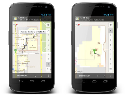
Since we launched indoor maps in the U.S. and Japan in Google Maps for Android last November, business owners have been adding their floor plans to our maps with Google Maps Floor Plans. Today, we are launching indoor walking directions for participating venues in these countries. This will help you get directions not only to a building’s front door, but also through those doors to the places where you want to go inside.

Indoor walking directions
Get Indoor walking directions in indoor maps (photo: Macy’s San Francisco)

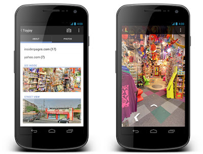
With Google Business Photos you can explore panoramic photos of the inside of a business from the palm of your hand. Now you can get a feel for a restaurant or store inside as well as outside using Street View technologies. To access these 360-degree panoramic views, look for the “See Inside” section on the Place page of select businesses.

Business Photos
See the interior of participating businesses with Business Photos (photo: Toyjoy)

Download Google Maps 6.7 for Android from Google Play, and use it as your trusted guide to help you find and discover places to eat, shop and play! You can also learn more about other great features on the Google Maps YouTube channel.


Since April 2010, we’ve been testing and developing the Business Photos program, which gives users a virtual peek inside businesses through interactive 360-degree imagery. After hearing your positive feedback ...

Since April 2010, we’ve been testing and developing the Business Photos program, which gives users a virtual peek inside businesses through interactive 360-degree imagery. After hearing your positive feedback about how showing off panoramic views of your business interiors helps you attract potential customers, we’re excited to announce further expansion of this program. Starting today, in addition to the United States, the United Kingdom, Australia, New Zealand and France, this service is now available in Canada, Ireland and the Netherlands.

Through the Business Photos program, if you’re a business owner in any of these locations around the world, getting started is easy. Just hire a Trusted Photographer in your area to take pictures of your establishment at a time convenient for you. Panoramas are created using the photos, and customers can easily find the resulting panoramic images on Google.com, on Google Maps, and on your Google Places listing. This self-service model, introduced several months ago, not only supports talented photographers in your local community, but also gives people who are thinking about visiting your location a sense of what they can expect when they walk through your doors. And if a local photographer isn’t yet available in your neighborhood, let us know so we can figure out where else to expand the program.

And whether you’re a professional photographer or an enthusiastic amateur, we’d love to have you on board! We are actively recruiting more Trusted Photographers to bring imagery of more local businesses online for millions across the globe to see. Visit our website for photographers to learn more and sign up.


View Larger Map
Click and drag to view the inside of Casa Artelexia in San Diego, California


And if you’re simply curious and want to explore businesses — from top-rated restaurants to exotic pet stores — check out this gallery of interior business photos on the Street View website.

Posted by Gadi Royz, Product Manager, Google Maps
  翻译: