The weather’s heating up, kids are out of school, and that means only one thing: summer’s officially here. Summer brings weekend road trips, faraway escapes and all kinds of getaways in between. And with the latest update to Google Maps, we're introducing two new features to get you where you’re going and help you remember your travels in a brand new way.

Road trip warriors can now get multi-stop directions in Google Maps on Android (coming soon to iOS). Just open the app, enter a destination, tap the corner menu, and then click “Add a stop”. To rearrange the order of your stops, tap and hold the three dot menu to the left of “Add stop” and drag it to the position you want – you can even search for types of places like gas stations or restaurants like you normally would. Once you’ve added all your stops, tap “Done” and your multi-stop route is complete. When you enter navigation mode you’ll have the same seamless driving experience you’re used to, whether you’re going from errand to errand or hitting scenic spots along Route 66.


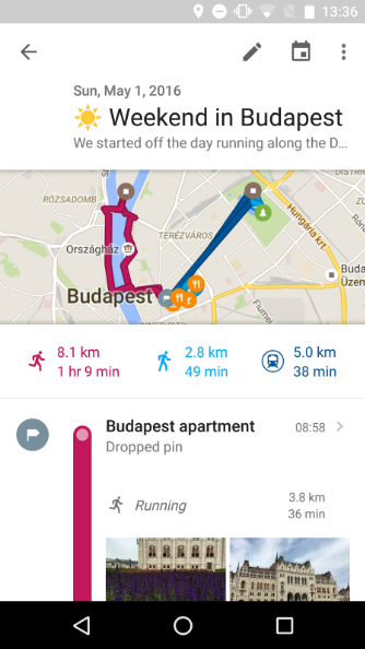
A lot of the fun of traveling is the memories created while exploring new places with friends, family or even solo. Pictures are a traditional way to remember those moments, but now Your Timeline users on Android can preserve their travel memories and info in a new way. Google Maps users with Location History enabled can open Your Timeline, select a date from their recent vacation or everyday life and add notes to help remember what they did that day—or save important notes for later.


No matter where your travels take you this summer and beyond, these new Google Maps features will get you there and help keep track of all the memories you make along the way.

Posted by Liz Davidoff, Communications Manager, Google Maps


Post authored by: Chris Herwig, Program Manager, Google Earth Engine
Three years ago we introduced a cloud-free mosaic of the world in Google Earth. Today we’re rolling out an even more beautiful and seamless version, with fresh imagery from Landsat 8 satellite and new processing techniques for sharper images than ever before. Satellite images are often cloudy, but not always over the same place, so we looked at millions of images and took the clearest pixels to stitch together this cloud-free and seamless image.
Columbia Glacier, Alaska
Detroit, Michigan
Swiss Alps, Switzerland
Higher Quality Imagery
Landsat 8, which launched into orbit in 2013, is the newest sensor in the USGS/NASA Landsat Program—superior to its predecessors in many ways. Landsat 8 captures images with greater detail, truer colors, and at an unprecedented frequency—capturing twice as many images as Landsat 7 does every day. This new rendition of Earth uses the most recent data available -- mostly from Landsat 8 -- making it our freshest global mosaic to date.


In the new view of New York City, details like skyscrapers, building shadows, and baseball and softball fields in Central Park shine through.


Our previous mosaic used imagery from Landsat 7 only, which at the time was the best imagery of its kind. Unfortunately, Landsat 7 images captured after 2003 were affected by a hardware failure, resulting in large diagonal gaps of missing data You can see this effect in the subsets of two Landsat 7 images captured over Oklahoma City, OK, in 2000 and 2003.

July 9, 2000

September 20, 2003
Processing imagery with Earth Engine
To produce this new imagery, we used the same publicly available Earth Engine APIs that scientists use to do things like track global tree cover, loss, and gain; predict Malaria outbreaks; and map global surface water over a 30 year period.


Like our previous mosaic, we mined data from nearly a petabyte of Landsat imagery—that’s more than 700 trillion individual pixels—to choose the best cloud-free pixels. To put that in perspective, 700 trillion pixels is 7,000 times more pixels than the estimated number of stars in the Milky Way Galaxy, or 70 times more pixels than the estimated number of galaxies in the Universe.
Lake Balkhash, Kazakhstan


Screen Shot 2016-06-23 at 3.31.37 PM.jpg
Brasilia, Brazil
Open data is good for everyone
This update was made possible in a large part thanks to the Landsat program and its commitment to free and accessible open data. Landsat, a joint program of the USGS and NASA, has observed the Earth continuously from 1972 to the present day and offers a wealth of information on the changes to the Earth's surface over time. And it's all available in Earth Engine!

The new imagery is now available across all our mapping products. To check it out, open up Google Earth, or turn on the satellite layer in Google Maps.

Post authored by: Chris Herwig, Program Manager, Google Earth Engine

Join us in celebrating the start of summer in the Northern Hemisphere—the longest and brightest day of the year, when the Northern Hemisphere is tilted towards the sun more than any other day. Among the many gifts that summer brings—longer days, warm walks, and late evening dinners—solar energy is a largely underutilized benefit.

The sun delivers more energy to Earth in one hour than civilization uses in a whole year. On this long Summer Solstice day, solar panels on your roof could generate enough energy to run your refrigerator for almost two weeks—that’s 50 percent more energy than the average day. Yet globally only about 1 percent of our energy comes from solar. So today, Project Sunroof teamed up with the Sierra Club to share some tips on how you can better use the sun to generate energy and protect our Earth.

sunroof-gif-1.gif

Solar energy is one of the cleanest energy sources available, and the U.S. has abundant solar resources. Project Sunroof is our attempt to make going solar a little easier. Homeowners can search their property and get a solar recommendation based on roof size, the amount of sun that hits it throughout the year, weather, applicable government incentives, and electricity rates and bill.

sunroof-gif-2.gif

Whether or not solar is an option for you, the Sierra Club has some additional tips on how to use the power of the sun and other forms of clean energy to slow the impacts of climate change. Check out Ready for 100 to learn more about how you can help us achieve 100% clean, renewable energy across the United States.
SUN-6.gif


Posted by Carl Elkin, Founder of Sunroof

The countdown to the 2016 Rio Olympics is underway and the Google Maps team is making moves to ensure that Rio residents and Olympics tourists are able to navigate and explore the city. Whether you’re a Rio local looking to expand your palate beyond your favorite neighborhood restaurants or a traveler wanting to choose from all the restaurant options nearby, you can now look to Google Maps’ Explore feature for local suggestions when in Brazil.


The Explore experience in Brazil is very much like the experience here in the US and is available on both iPhone and Android. Simply open Google Maps on your mobile phone and tap “explore food & drinks near you” at the bottom of the screen. Depending on where you are and time of day, a category (breakfast, lunch, coffee, dinner and drinks) is preselected for you. Google Maps will share lists of food and drink locations around you, ranging from “best breakfasts” to “waterside dining”. Once you find a list that fits your needs, just tap on the list to see suggested locations. Then swipe right or left to see more options and tap “read more” or the arrow at the bottom of the screen to select a venue and get more details. Of course you'll see these on-screen prompts like "explore food & drinks near you" in the language you’ve set as primary on your mobile phone.

For those of you not heading to Rio this summer, you can still use Explore to discover new places around the world. Explore is also available on Android and iPhone in the US, UK, France, Germany, Italy, and Japan. And it was just recently made available in Australia and Canada as well.

Posted by Bryan Cheng, Product Manager, Google Maps
  翻译: