The National Geotechnical Properties Database (NGPD) primarily holds data and information from commercial site investigations carried out for civil engineering purposes, including:
- borehole details
- lithological description
- field and laboratory geotechnical tests
- engineering
- environmental chemical testing
A full description of the database structure and fields can be found in The structure and operation of the BGS National Geotechnical Properties Database.

Figure 1 BGS NGPD coverage. BGS © UKRI. Contains OS data © Crown copyright 2020.
Where does the data come from?
The distribution of our data holdings (Figure 1) often follows major UK infrastructure developments and the coverage of our research, including UK rocks and soils engineering geology studies or the areas covered by ground information for sustainable development and geohazards projects.
Much of the data is from site investigations for major trunk road construction schemes, often provided by Highways England (formerly the Highways Agency) and other major engineering projects. A small proportion of the data is from BGS laboratory test results.
The final investigation data and information are supplied to BGS by clients, consultants and contractors either as final paper records or as Association of Geotechnical and Geoenvironmental Specialists (AGS) digital data transfer format files. AGS digital data transfer format files (.ags) are the preferred method of receiving data because they can be added to the database much more quickly and accurately than adding data by hand from paper records.
BGS has an AGS file utilities tool and API available to validate your AGS files against the AGS v4.x standard and BGS data deposit requirements.
- Please contact BGS Enquiries for advice on depositing your data.
What do we do with the data?
Our engineering geology studies include analysis and the collation of the geotechnical properties in to technical reports covering formations important to strategic UK development and construction. These can be downloaded and include:
History and evolution of the database
In the mid-1980s to the early 1990s, data was stored in a series of flat file geotechnical datasets (paper, then spreadsheet) generated for the applied geology mapping projects of urban areas and funded by the then Department of the Environment. These were inefficient to use and difficult to manage. The availability of personal computers and networking enabled the decision to create and populate a relational database. This is now the National Geotechnical Properties Database, with 54 data tables and 33 dictionary tables. The dictionary tables are used to define and constrain fields in the database that describe the project, boreholes, core and any in-hole or laboratory test information relating to the material investigated.
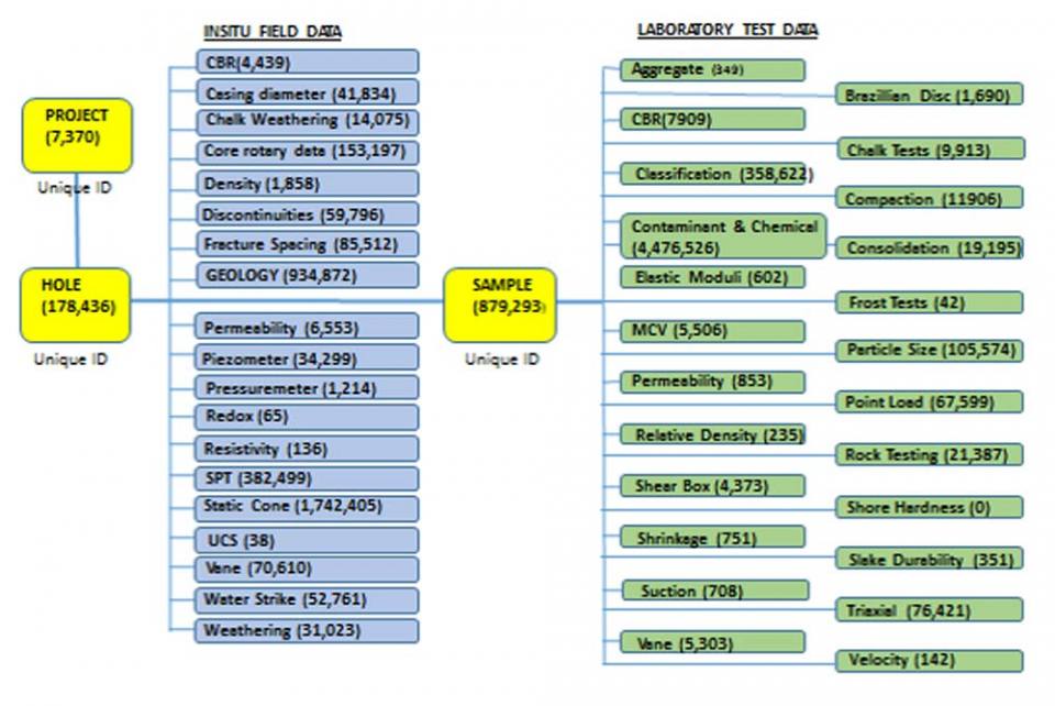
Figure 2 outlines the design of the database, which is a hierarchical structure currently based on the AGS industry standard for electronic transfer of geotechnical and geoenvironmental data (version 3.1).
The database contains data relating to the project, the boreholes and pits within the report (including British National Grid reference), in situ measurements (including geology with full text description) and laboratory results of tests on samples.

The database contains records for 7370 projects (site investigation reports). Linked to the reports are 178 436 holes. There are a total of 3 617 186 in situ field records and 879 293 samples linked to the holes, with a total of 5 180 330 laboratory test data records.
Lithology and lithostratigraphy codes are populated for the geological interval in the geology table (‘GEOLOGY’ in Figure 2). They are extracted from the AGS files (where available) or added by BGS geologists (where not available). Some of the original codes supplied by contractors may have been changed in the geology table by BGS geologists as part of our QA procedures, ensuring standard formats are maintained and promoting property attribution to geological stratigraphy.
The information within the database forms the basis for the geotechnical attribution of 2D and 3D digital geological models and underpins our core and commissioned engineering geology research.
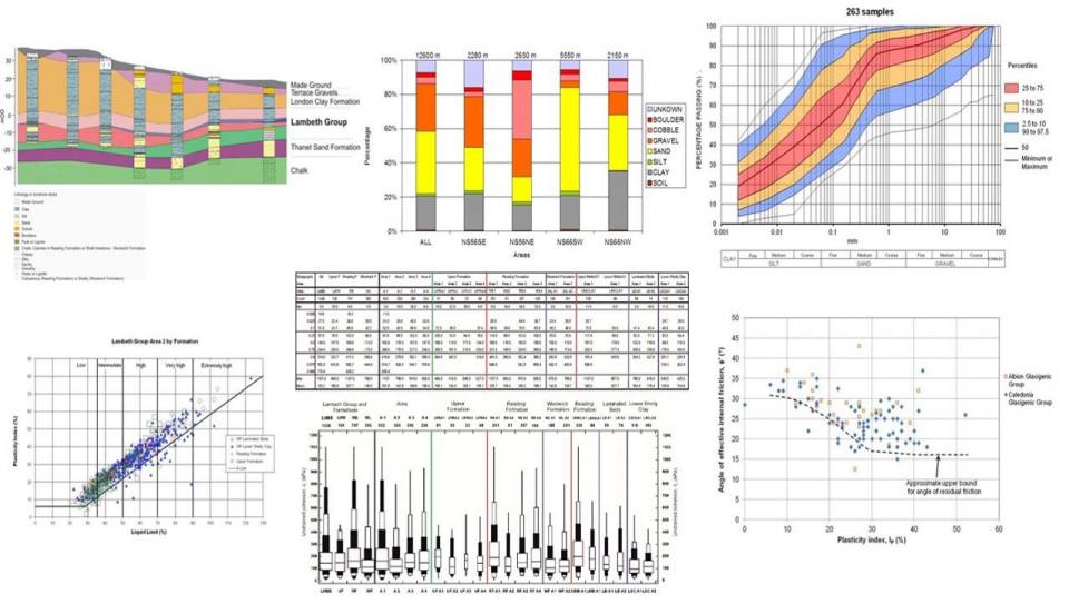
Statistical analysis, for example to assess property variation with depth, is performed on the data and is provided in our technical reports in the form of geotechnical property distributions across different depositional basins of some of the UK’s key formations*. Presentation of the data from the NGPD can be customised for each specific application, as in Figure 3, showing:
- property distribution summaries in box and whisker form;
- index property classifications on standard charts (A-line-plasticity; particle size)
- interpreted geological sections

The data has been used for:
- engineering geology of British rocks and soils
- ground information for sustainable development primarily in Glasgow, London and Manchester
- geohazards projects
- regional geotechnical and hydrogeological assessments
- BGS ground conditions (resistivity, pipe leakage impacts, corroded asset failure and BGS Civils – bulking volume, corrosivity, engineered fill, foundation conditions, strength, sulfate/sulfide)
- georeports and enquiries
* For details of the statistical analysis techniques see The statistical analysis and summarisation of geotechnical databases.
Engineering geology of British rocks and soils:
Ground information for sustainable development:
In order to further improve the national coverage of the database and its usefulness, BGS would be very grateful to receive site investigation data in AGS file format. Deposit your AGS data using the Data Deposit Portal. In order to increase the usefulness of the data even further, there is an option when depositing the data for it to be deposited as Open Access to allow it to be shared with 3rd parties.
Contact
Contact Marcus Dobbs for further information about the National Geotechnical Properties Database.
Relative topics
You may also be interested in

Science facilities
BGS operates and maintains a wide range of state-of-the-art laboratories and other facilities, which underpin virtually all of our research.

Engineering and Geotechnical Capability
Leading the development and application of field and laboratory infrastructure and long-term management of geophysical and geotechnical property data.


