|
|


|
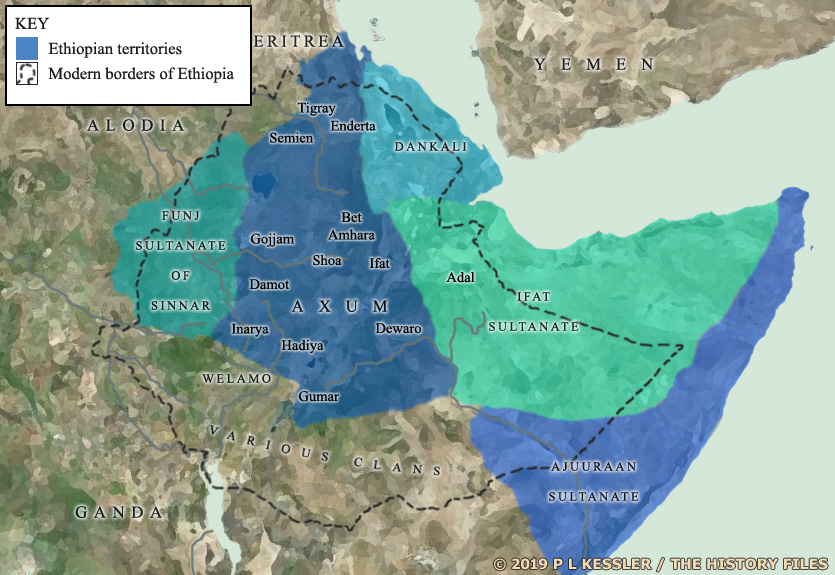
Map of Ethiopia AD 1300s-1600s |
|
Late medieval Ethiopia in the form of the kingdom of Axum was not the Ethiopia of today, with its fixed borders and relatively large volume of territory. Imperial Ethiopia was much smaller and its borders were constantly shifting. Axum was surrounded by minor regions and kingdoms which bickered and fought between themselves and with the Solomonic emperors of Axum. Most of those within the blue area on the map were Christian Ethiopians themselves, some with closer links to the throne at Axum and some who were antagonistic towards it. Many of the larger surrounding states were Muslim, inherently antagonistic towards Ethiopia's Christians. The empire's history is one of gradual expansion, defeating its local opponents minor kingdom by minor kingdom. Even then these vassal kingdoms often retained their own kingship for quite some time afterwards. Full central control of the empire was a comparatively recent phenomenon. A clickable version of this map is available for desktop displays. To select a territory for further information, click anywhere within its borders.
Map navigation: |
|
Original text and map copyright © P L Kessler and the History Files. An original feature for the History Files. Go back or return home. |