|
|


|
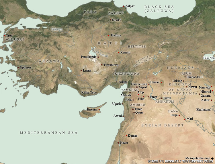
Map of Anatolia and environs 2000 BC |
|
The start of the second millennium BC saw the ancient Near East undergoing a period of collapse. Due to a mixture of failing harvests, population decline, and invasion, the Third Dynasty of Ur in southern Mesopotamia had been swept away, and the repercussions also seem to have hit Syria. While Amorite states fought over the scraps of Sumer, in northern Syria the number of settlements underwent a reduction, probably caused by an economic downturn, and it took two centuries for the region to recover. Once that recovery was underway, from about 1800 BC, many new states appeared in Syria and northern Mesopotamia as Amorites and newly arrived Hurrians made their presence felt. The Kingdom 'of Upper Mesopotamia' briefly unified much of the region in a foretaste of the Mitanni domination of the same territories which would take place by about 1500 BC. After its fall, the state of Yamkhad dominated Syria until about 1595 BC. Further north, in Anatolia, a series of small city states which had existed for perhaps a millennium now began to emerge from obscurity. A new people, the Hittites, were arriving, probably from the Caucasus, and they began carving out a space for themselves. In southern and western Anatolia, Luwians had dominated since about the twenty-third century BC, and by around 1600 BC two Luwian states began to emerge as they encountered the Hittites and Mitanni. In the far west, although the city of Troy had been in existence for over 1,400 years, that too only began to appear in records from around 1600 BC onwards. Previous to that it had been home to a relatively basic civilisation, with little writing of its own. The limited levels of knowledge regarding all of these states reveals a lack of records, even from the Hittites to an extent, especially when compared to Syria and Mesopotamia. Main sources A clickable version of this map is available for desktop displays. To select a state for further information, click on its name.
Map navigation: |
|
Original text and map copyright © P L Kessler
and the History Files. An original feature for the History Files. |