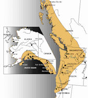
Pacific Northwest
 Cold, clear mountain streams tumble down rock-strewn courses. The destination: a rugged, unused coastline where precipitous, fog-enshrouded cliffs rise out of pounding surf. Mountains are visible in the distance--lofty, majestic, covered with snow. Tall needleleaf evergreens cover the land between with a mantle of green. Cities, where they exist, give the impression that they are new. This is America's North Pacific Coast, or more popularly, the Pacific Northwest - the coastal zone that stretches from northern California through coastal Canada to southern Alaska.
Oregon and Washington host a diversity of ecosystems and ecoregions from wet temperate rain forests in some coastal areas to the more arid high desert areas of eastern Oregon and Washington. The Pacific Northwest Region is bound by the Pacific Ocean to the west and includes several mountain ranges: the Coast Mountains, the Cascade Range, the Olympic Mountains, and the Columbia Mountains. Active volcanoes within the Oregon and Washington region include Mount Baker, Mount Rainier, Mount St Helens, which erupted in 1980, Mount Hood, and Mount Jefferson. Most of the human population of the Pacific Northwest is currently concentrated in the Vancouver�Seattle�Portland corridor.
An important element of its regional character is the North Pacific Coast's relative isolation from the rest of America. Less than 3 percent of the American population lives there. Populated sections of the region are separated from the other principal population centers by substantial distances of arid or mountainous terrain. Residents of the region often view this isolation as positive, a geographic buffer against the rest of the world. Economically, however, it has been a hindrance. High transportation costs inflate the price of Pacific Northwest products in distant eastern markets and discourage some manufacturers from locating in the region.
Climate and ecology in the Pacific Northwest are largely influenced by the interactions between seasonally varying atmospheric circulation patterns, or weather, and the mountainous terrain within the region. Large-scale atmospheric circulation occurring over the Pacific Ocean, including the Gulf of Alaska, is the driving influence of seasonal variations in precipitation and weather. Approximately two-thirds of the Pacific Northwest precipitation occurs during half of the year (October-March) from the Pacific storm track, and much of this precipitation is captured in the region�s mountains. Precipitation declines from late spring to early fall with high pressure systems to the west, generally keeping the northwest fairly dry.
Contrasts in Pacific Northwest climate can be stark owing to the region�s mountains, especially the Cascade mountain range. The Cascades create a barrier between the maritime climate influences to the west, where temperatures are generally mild year-round, and the continental climate influences to the east, with more sunshine and larger daily and annual ranges in temperature.
Important fluctuations in regional climate are related to the El Ni�o/Southern Oscillation (ENSO) and Pacific Decadal Oscillation (PDO) phenomena. In their warm phases, ENSO, El Nino and PDO increase the odds for a warmer-than-average Pacific Northwest winter and spring and decrease the odds for a wetter-than-average winter. The opposite tendencies are true for cool phase ENSO (La Ni�a) and PDO.
|
NEWSLETTER
|
| Join the GlobalSecurity.org mailing list |
|
|
|

