Scientists have compiled the most comprehensive map yet of tectonic stress magnitudes across North America, highlighting regions most vulnerable to earthquakes.
The map and associated study, published today in Nature Communications, showcase the dynamic subterranean forces at play on a continental scale.
Writing in their paper, the authors of the new study, Jens-Erik Lund Snee, a postdoctoral fellow with the U.S. Geological Survey, and Mark Zoback, a geophysicist at Stanford University, say it’s “the first comprehensive view of the relative principal stress magnitudes throughout North America.”
The new map incorporates thousands of horizontal stress orientations, revealing the directionality of high-pressure zones within the continent’s crust. This allowed them to pinpoint seismic hotspots across North America.
Geologists and other scientists will be able to use this work for various modeling studies, but it also serves the practical purpose of alerting jurisdictions to seismic risks. Incredibly, the new maps don’t just highlight areas prone to earthquakes—they also reveal the types of earthquakes these places can expect.
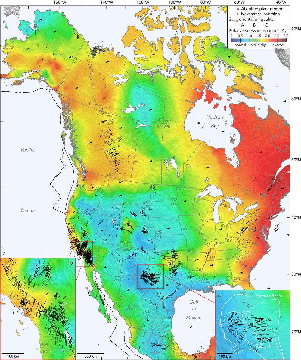
In addition to highlighting previously known earthquake risks (especially in California, New Mexico, and Texas), the map includes areas made susceptible to earthquakes on account of human activity, namely fracking (Oklahoma and Texas—we’re looking at you). This information could consequently be used to inform energy companies about the hazards of drilling in certain areas and to attempt to mitigate risks.
“If you know an orientation of any fault and the state of stress nearby, you know how likely it is to fail and whether you should be concerned about it in both naturally triggered and industry-triggered earthquake scenarios,” explained Lund Snee in a press release. “We’ve detailed a few places where previously published geodynamic models agree very well with the new data, and others where the models don’t agree well at all.”
To create the map, the researchers amassed over 2,000 stress orientations taken across North America, of which 300 are brand new. These measurements were taken from boreholes—long, narrow shafts drilled into the ground for geophysical analysis. The authors also assessed faults based on a locality’s prior earthquake history. This provided for a highly granular view of the seismic situation at local levels, but also across the entire North American continent.
Looking at the map, the black lines show areas of maximum horizontal stress, and the black arrows indicate the directionality of the plates. Colors represent the style of faulting found in a particular region, in which bluish areas experience normal faulting (where the crust stretches horizontally), greenish-yellow areas experience strike-slip faulting (vertical fractures where blocks mostly move horizontally), and reddish areas experience reverse faulting (where fractures move atop another).
Each fault style produces its own distinctive shaking during an earthquake, highlighting another valuable aspect of this map, as Jack Baker, a professor of civil and environmental engineering at Stanford University, pointed out in the press release.
“In our hazards maps right now, in most places, we don’t have direct evidence of what kind of earthquake mechanisms could occur,” said Baker, who wasn’t involved in the new study. “It’s exciting that we have switched from this blind assumption of anything is possible to having some location-specific inferences about what types of earthquakes we might expect.”
The new research has already yielded some interesting findings. In the western U.S., for example, pronounced changes to stress types and orientations were seen across short distances, sometimes measured in tens of miles—a level of detail not exposed in previous maps.
Another surprising finding has to do with relatively low rebound stresses seen across the continent. When the massive ice sheets melted at the end of the last ice age some 20,000 to 12,000 years ago, this unleashed a lot of pent-up seismic energy, a process that’s still ongoing. Or so scientists thought. The new research shows that postglacial rebound pressures are lower than those seen in crusts along faults.
“We see things we’ve never seen before that require geologic explanation,” said Zoback. “This will teach us new things about how the Earth works.”
